Florin Ciocan, Catalin Manu, Alexandru Matache, Nicolae Petrescu, George Muratoreanu
ABSTRACT. The field research took place between 2019 and 2020, in the upper river basin of the Raul Alb creek, located in the northwest of Dambovita County, the analysed land area being 4034 ha. Underlying the research of the complex erosion phenomena faced by the analysed territory was the soil survey, which consisted of sampling 46 soil profiles in the representative areas for the analysed territory. For the analysis of the soil fertility, chemical analyses were performed regarding the pH, humus content, reported to the soil texture in the topsoil and the supply of nutrients (nitrogen, phosphorus and potassium), also physical-mechanical analysis (soil texture), interpreted according to the “Methodology for the Development of Pedological Studies, Volumes I, II, III, 1987”. By centralising the obtained results, it found that 59.42% of the total analysed land surface had a weak alkaline pH, at least in the topsoil, due to the CaCO3 content. For the supply of humus, the most significant share is that of the extremely low-supplied soils with this element in the topsoil, i.e. 73.42% of the mapped area, and in terms of the nitrogen supply, 26.67% of the total surface of the river basin shows severe deficiencies in this element. The situation is worrying indeed in the case of the supply of soils with mobile phosphorus, with 3 280.27 ha of the mapped surface having very low or low contents of this element, making up 81.31%. However, for potassium, the soils from the upper sector of the Raul Alb catchment are mostly moderately and well supplied, with only 620.85 ha (15.39%) being extremely poorly supplied with this element.
Keywords: river basin, mineral nutrients, humus, soil pH.
Cite
ALSE and ACS Style
Ciocan, F.; Manu, C.; Matache, A.; Petrescu, N.; Muratoreanu, G. Soil fertility in the central-southern part of Romania expressed by soil reaction and nutrient content: a case study from the Raul Alb catchment, Dambovita County. Journal of Applied Life Sciences and Environment 2021, 54(4), 377-388.
https://doi.org/10.46909/journalalse-2021-033
AMA Style
Ciocan F, Manu C, Matache A, Petrescu N, Muratoreanu G. Soil fertility in the central-southern part of Romania expressed by soil reaction and nutrient content: a case study from the Raul Alb catchment, Dambovita County. Journal of Applied Life Sciences and Environment. 2021; 54(4): 377-388.
https://doi.org/10.46909/journalalse-2021-033
Chicago/Turabian Style
Ciocan, Florin, Catalin Manu, Alexandru Matache, Nicolae Petrescu, and George Muratoreanu. 2021. “Soil fertility in the central-southern part of Romania expressed by soil reaction and nutrient content: a case study from the Raul Alb catchment, Dambovita County” Journal of Applied Life Sciences and Environment 54, no. 4: 377-388.
https://doi.org/10.46909/journalalse-2021-033
View full article (HTML)
Soil Fertility in the Central-Southern Part of Romania Expressed by Soil Reaction and Nutrient Content: A Case Study from the Raul Alb Catchment, Dambovita County
Florin Ciocan1*, Catalin Manu1, Alexandru Matache1, Nicolae Petrescu1, George Muratoreanu2
1University of Agronomic Sciences and Veterinary Medicine of Bucharest, Romania
2Valahia University of Targoviste, Romania
*E-mail: florinciocan74@yahoo.com
Received: Dec. 02, 2021. Revised: Apr. 18, 2022. Accepted: Apr. 20, 2022. Published online: May 13, 2022
ABSTRACT. The field research took place between 2019 and 2020, in the upper river basin of the Raul Alb creek, located in the northwest of Dambovita County, the analysed land area being 4034 ha. Underlying the research of the complex erosion phenomena faced by the analysed territory was the soil survey, which consisted of sampling 46 soil profiles in the representative areas for the analysed territory. For the analysis of the soil fertility, chemical analyses were performed regarding the pH, humus content, reported to the soil texture in the topsoil and the supply of nutrients (nitrogen, phosphorus and potassium), also physical-mechanical analysis (soil texture), interpreted according to the “Methodology for the Development of Pedological Studies, Volumes I, II, III, 1987”. By centralising the obtained results, it found that 59.42% of the total analysed land surface had a weak alkaline pH, at least in the topsoil, due to the CaCO3 content. For the supply of humus, the most significant share is that of the extremely low-supplied soils with this element in the topsoil, i.e. 73.42% of the mapped area, and in terms of the nitrogen supply, 26.67% of the total surface of the river basin shows severe deficiencies in this element. The situation is worrying indeed in the case of the supply of soils with mobile phosphorus, with 3 280.27 ha of the mapped surface having very low or low contents of this element, making up 81.31%. However, for potassium, the soils from the upper sector of the Raul Alb catchment are mostly moderately and well supplied, with only 620.85 ha (15.39%) being extremely poorly supplied with this element.
Keywords: river basin, mineral nutrients, humus, soil pH.
INTRODUCTION
Fertility, or the productive potential of the soil, is a basic property that ensures good growth and normal development of plants through a simultaneous, continuous and cumulative action of all the factors that make up its ecological complex (Jones et al., 2005). Soil fertility can be natural when it is due only to environmental factors, or cultural when triggered by human action through various works (Rolando et al., 2018).
This fundamental characteristic is related to the amount of humus contained in the soil, but also by its quality. Calcium mull-type humus is the best in terms of quality and most conducive to plant growth and development (Gilmour, 2020). Furthermore, soil fertility is defined by its reaction and the degree of supply of nutrients (nitrogen, phosphorus and potassium) and by the ratio between these in the soil. Knowing all these aspects regarding the fertility status of soils in hydrographic basins in hilly and mountainous areas requires complex information, both pedological and morpho-dynamic in nature, pertaining to the researched areas (Bucur and Lixandru, 1997).
The pedological information are obtained by researching the natural environment in which soils are formed and evolve, taking soil samples, chemically analysing them and interpreting the results according to the methodologies in use. In recent decades, the trend to include in soil research the study of the physical conditions in which they evolve increased, because of the close interaction between soil and land in the process of pedogenesis, trend started from Dokuceaev’s research, which has been the basis of modern soil science since 1883. The concept of soil-land has been generalised both at the level of soil study methodologies in Romania (Florea et. al., 1987) and of international ones, such as the SOTER methodology.
The morpho-dynamic information comes from the analysis of the two groups of morpho-dynamic factors that can influence the degree of soil fertility: causal factors (precipitation, temperature, wind, hydrologic conditions and anthropogenic activity) and conditional factors (the geology of the area, landforms and land cover). On mountain slopes, the thickness of the fertile horizon on the soil surface are directly influenced by the start of surface erosion processes, which evolve over time, deeply affecting the soils (Sevastel et. al., 2015).
The soil horizon in a region, as well as that on the entire planet, is quantitative limited by the respective geographical expansion, and when rationally exploited it can increase its productive potential (Blair et al., 2006).
The objectives of this paper are to identify the degree of soil fertility in the upper basin of the Raul Alb Creek, expressed by the state of supply of humus, nitrogen, phosphorus and potassium, correlated with several physical-mechanical (soil texture) and chemical (soil pH) factors.
MATERIALS AND METHODS
The Location of the Researched Area
The hydrographic basin of Raul Alb Creek is located in the central-southern part of Romania, within Dambovita County, more precisely in its northwestern part (Fig. 1). The research in this river basin was carried out in its upper part, up to where it meets the Bărbulețu Creek valley, which stretches over 4 034 ha. The relief of the area is represented by the Curvature Subcarpathians, having the White River river basin located in their western extremity, more precisely in the subgroup of the Ialomita Subcarpathians. The northern sector of the watercourse also includes the southern extremity of the Leaota Mountains, as the stream has its source in Plaiul Gavana. The maximum altitude in the north of the river basin is 1 044 m, reaching 433 m at the confluence with Bărbulețu Creek in its southern part. The result is altitudinal amplitude of 611 m, which, correlated with a length of the researched sector of 13.55 km, generates an average slope of 4.5%. Raul Alb Creek has the cadastral code X-1.25.13; it is a sinuous watercourse, strongly meandering and is a tributary on the left side of the Dambovita River.
The relief of the upper area of the Raul Alb catchment is strongly fragmented by numerous valleys, having on the right Vilcelului Valley, and on the left the Predeal, Puiusului, Horoaia, Ciobanesti, Stalpului, Barbosului and Licestilor Valleys, among others. They are joined by numerous glens, ravines and gullies with a high flow, which also collects the water of the coastal springs found on the slopes.
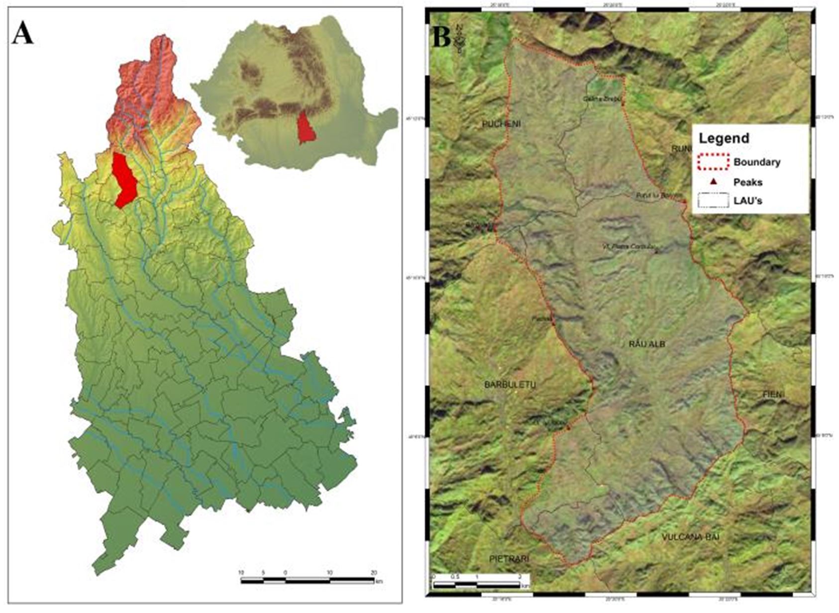
Figure 1 – A. The location of the Raul Alb river basin in Dambovita county; B. Satellite map displaying the geographical limits of the Raul Alb hydrographic basin, up to the confluence with Barbuletu Creek
The basic data on the pH and texture of the soils in the Raul Alb hydrographic basin, up to its confluence with Barbuletu Creek, as well as on their supplies of humus, nitrogen, phosphorus and potassium, resulted from the soil survey carried out between 2019 and 2020, which went through the three execution phases: the field phase, the laboratory phase and the in-office phase. The final goal of the research in the above-mentioned hydrographic basin is to use GIS methods to estimate as accurately as possible the risk of erosion processes and how they affect soil fertility.
To this end, 46 representative soil profiles were compiled, out of which 224 soil samples were taken, based on diagnostic horizons.
The soil survey was prepared according to the “Methodology for the Development of Pedological Studies, Volumes I, II, III, 1987”, while the definition of soil units and their classification into soil classes was performed according to SRTS+.
The creation of the Romanian Soil Taxonomy System (SRTS+) stemmed from the need to correlate the previous Romanian soil classification systems (SRCS-1980 and SRTS-2003) but also the completion of the SRTS-2012 system with new terms for describing the soils (upper and lower taxonomic qualifiers) (Vlad et. al., 2014).
Chemical and Physicomechanical Analysis Methods
The soil samples were chemically and physicomechanically analysed in the laboratory of the Dambovita Office of Pedological and Agrochemical Studies, using the “Methodology for the Development of Pedological Studies, Part III”.
To establish the reaction of the soils, their texture and the degree of supply of nutrients in the upper part, the following chemical and physicomechanical analyses were performed:
- the pH of the soil, using the potentiometric method in aqueous solution;
- the content of humus (%), using titrimetric dosing (the Walkley-Black method in the Gogoașă modification);
- the granulometric analysis or soil texture (5 fractions), using the Kacinski method;
- the nitrogen content (nitrogen index: I.N., %), resulting from a calculation;
- the mobile phosphorus content (ppm), using the Egner–Riehm–Domingo method;
- the mobile potassium content (ppm), using the ammonium chloride extraction method.
Developing the GIS Database
To create the primary database, we began with the topographic maps, on a scale of 1:25 000 and 5 m equidistance, which we scanned and georeferenced in the Stereo 70 projection system (Fig. 2). Data on the built areas were also used (the map of settlements, the boundaries of administrative units were based on Open Street Map apps).
By digitising the level sets and the hydrographic network, we created the digital elevation model (DEM), which had a resolution of 10 m, by using the ArcToolbox → Spatial Analyst Tools → Interpolation → Topo to Raster function of the ArcGIS 10.6.1 software, and its two components, ArcCatalog and ArcMap. Morphometric maps resulted in the subsequent research on soil fertility degradation due to erosion phenomena, starting from DEM (hypsometry, slopes and relief fragmentation as well as the density and depth of fragmentation) and morphographic data (slope orientation). Furthermore, the DEM was the basis on which the mapping of the shading of the slopes (Hillshade) has made, which was the starting point for the generation of the other maps, all of them at a resolution of 10 m.
The analysis of the erosional risk in the Raul Alb creek hydrographic basin has made using the method of weighted overlay analysis (WOA) of thematic maps (Ciocan et al., 2021).
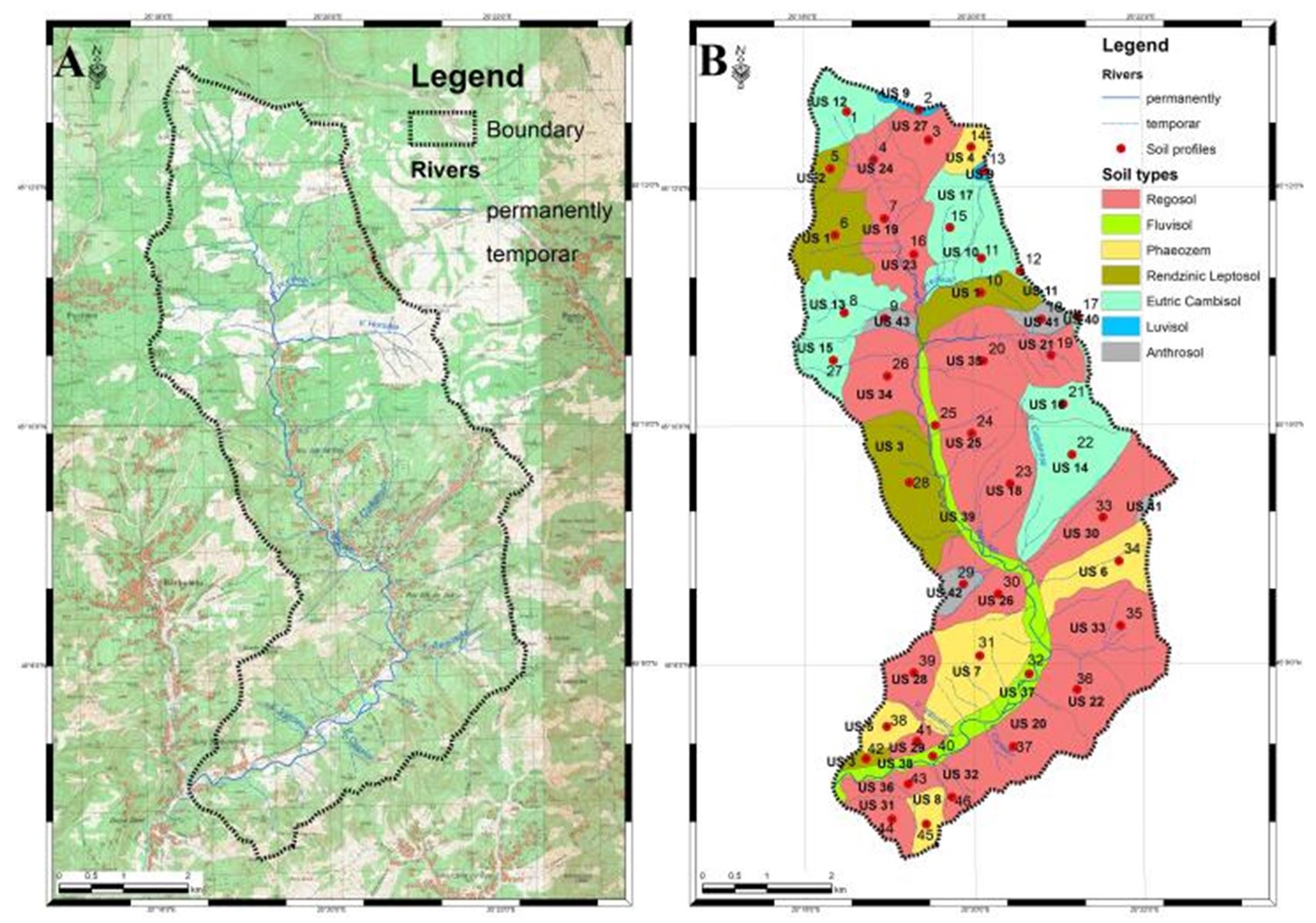
Figure 2 – A. The topographic map on a scale of 1:25 000 in the upper sector of the Raul Alb River basin; B. The map of soil types in the Raul Alb River basin, up to where it meets Barbuletu Creek, according to WRB – SR 2006
RESULTS
Soil Reaction (pH) in the Topsoil
The 4 034 ha analysed fall into the following soil pH classes (Fig. 3):
- moderately acidic reaction, 520.68 ha;
- weak acidic reaction, 487.31 ha;
- neutral reaction, 629.13 ha;
- weak alkaline reaction: 2396.88 ha.
The Supply of Soils with Humus in the Topsoil
In terms of the hydrographic basin, the total area of 4 034 ha is divided into soil supply classes with humus, in the topsoil, as follows (Fig. 4):
- extremely low supply, 56.49 ha;
- very low supply, 490.47 ha;
- low supply, 2 414.99 ha;
- average supply, 1 072.05 ha.
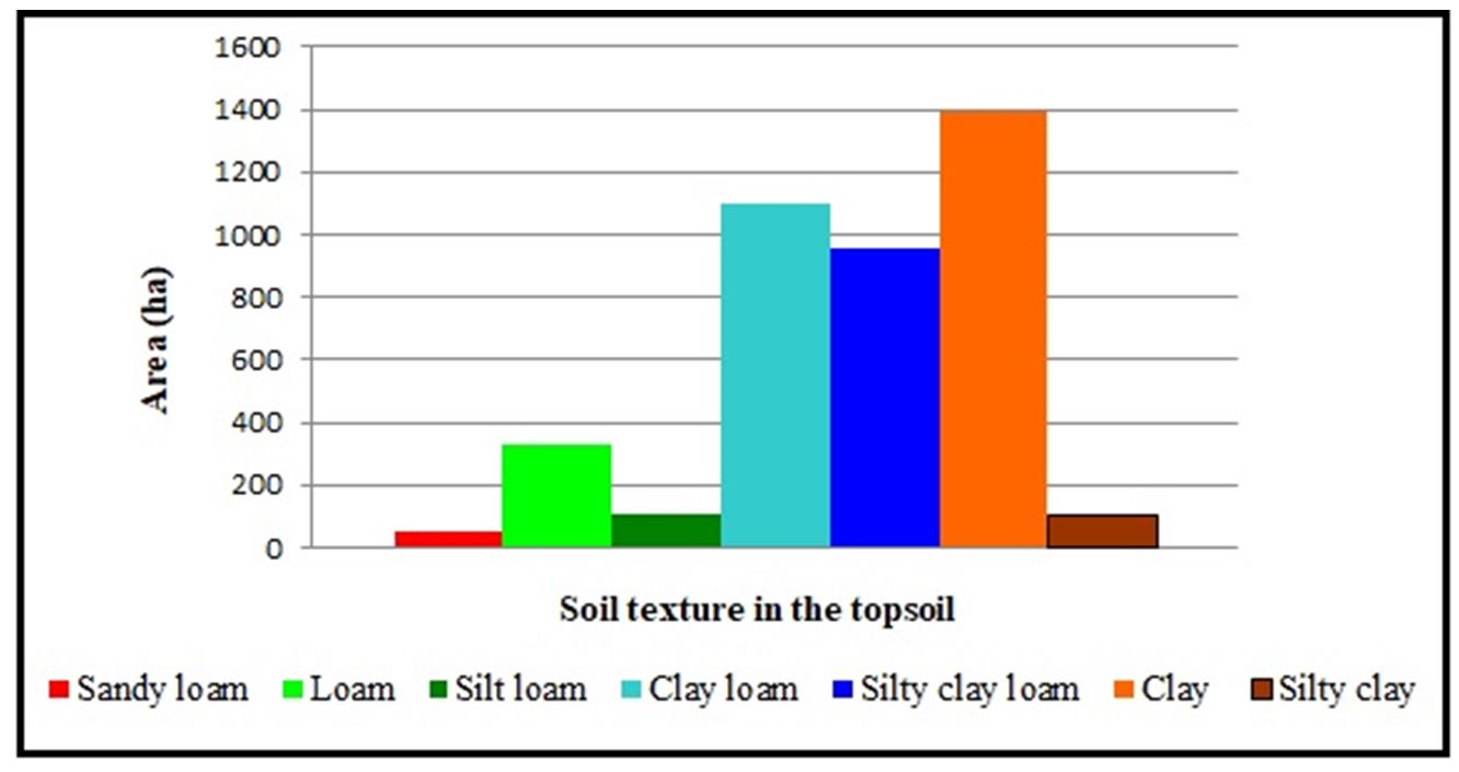
The Soil Texture in the Topsoil
For the 4 034 ha in surface area, the soils located in the upper part of the Raul Alb hydrographic basin are classified in textural classes as follows (Fig. 5):
- sandy loam, 47.30 ha;
- loam, 332.41 ha;
- silt loam, 110.18 ha;
- clay loam, 1 096.36 ha;
- silty clay loam, 954.08 ha;
- clay, 1 388.97 ha;
- silty clay, 104.70 ha.
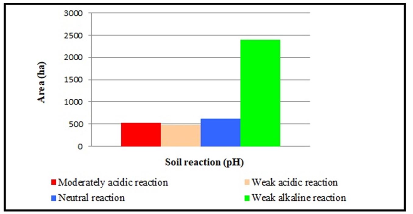
Figure 3 – The chart for the pH soils in the topsoil, according to Indicator 63 of the “Methodology for the Development of Pedological Studies, Part III”
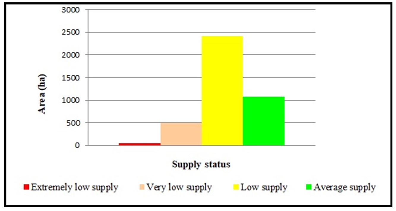
Figure 4 – The chart detailing the soil supply classes with humus in the topsoil, according to Indicator 70
The Humus Reserve in the 0–50 cm Horizon
Depending on the degree of humus supply of soils, another indicator for soil fertility has resulted, namely the humus reserve in the 0–50 cm horizon, expressed in t/ha. The basis of this calculation was the formula:
Humus reserve (t/ha) = ΣHUM H D.A., where HUM is the amount of humus present in the soil horizon (%), H is the thickness of the soil horizon (cm), and D.A. is the apparent density of the soil horizon (g/cm³).
The 4 034 ha surface area that is the object of the research falls into humus reserve classes, for cultivated soils, with medium and fine texture, as follows (Fig. 6):
- very small reserve, 91.49 ha;
- small reserve, 617.16 ha;
- average reserve, 1 209.04 ha;
- large reserve, 597.42 ha;
- very large reserve, 1 311.55 ha;
- extremely large reserve, 207.34 ha.
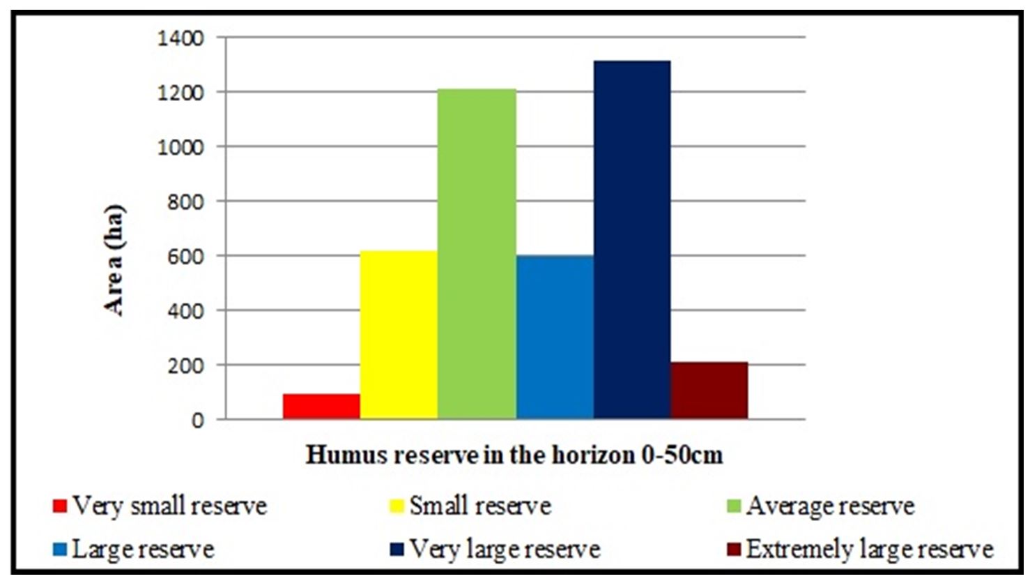
Figure 6 – The chart detailing the soil humus reserve classes in the 0–50 cm horizon, according to Indicator 144
The Supply of Soils with Nitrogen (I.N.) in the Topsoil
The supply status of soils with nitrogen was established by calculating the nitrogen index (I.N.), starting from the supply of humus (Table 1), by applying the formula:

where HUM is the humus content (%), and VAh is the degree of base saturation calculated with hydrolytic acidity.
At the level of the researched catchment, the average supply of nitrogen predominates in the first horizon of the soils, followed in value by the weak one, as follows (Fig. 7):
- low supply, 1 076.00 ha;
- average supply, 2 340.01 ha;
- good supply, 617.99 ha.
Table 1
Minimum and maximum values of the humus (H%) and the base saturation (V%) in the topsoil that influences the value of nitrogen index (I.N.)
|
No. Soil Unit (U.S.) |
No. Representative Soil Profile |
Humus supply H (%) |
Base saturation V (%) |
Nitrogen Index I.N. (%) |
|
|
Minimum values |
|||||
|
43 |
9 |
0.75 |
78.1 |
0.59 |
|
|
40 |
17 |
0.72 |
100 |
0.72 |
|
|
42 |
29 |
0.43 |
100 |
0.43 |
|
|
Maximum values |
|||||
|
33 |
35 |
5.66 |
100 |
5.66 |
|
|
14 |
22 |
4.87 |
70.7 |
3,74 |
|
|
31 |
44 |
4.84 |
95.6 |
4.63 |
|
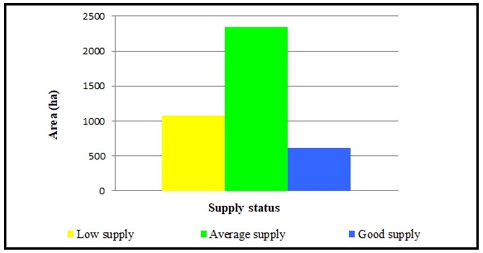
Figure 7 – The chart detailing the supply of soils with nitrogen (I.N.) in the topsoil, according to Indicator 142
The Supply of Soils with Mobile Phosphorus in the Topsoil
The supply of mobile phosphorus at the level of the researched area is predominantly low and very low (3280.27 ha), with only 753.73 ha not being affected by the deficiency in this element.
The total area of 4034 ha from the upper basin of the Raul Alb Creek can be grouped in classes for the mobile phosphorus supply in the upper horizon as follows (Fig. 8):
- very low supply, 1 483.93 ha;
- low supply, 1796.34 ha;
- average supply, 611.02 ha;
- good supply, 142.71 ha.
The Supply of Soils with Mobile Potassium in the Topsoil
For the supply of mobile potassium in the topsoil, the soils in the studied area have a good or very good potassium supply over an area of 1 977.15 ha out of a total of 4 034 ha, while a land area of 620.85 ha has a potassium deficiency, the situation at the basin level being the following (Fig. 9):
- extremely low supply, 84.90 ha;
- very low supply, 35.00 ha;
- low supply, 500.95 ha;
- average supply, 1 436.00 ha;
- good supply, 1 564.43 ha;
- very good supply, 412.72 ha.
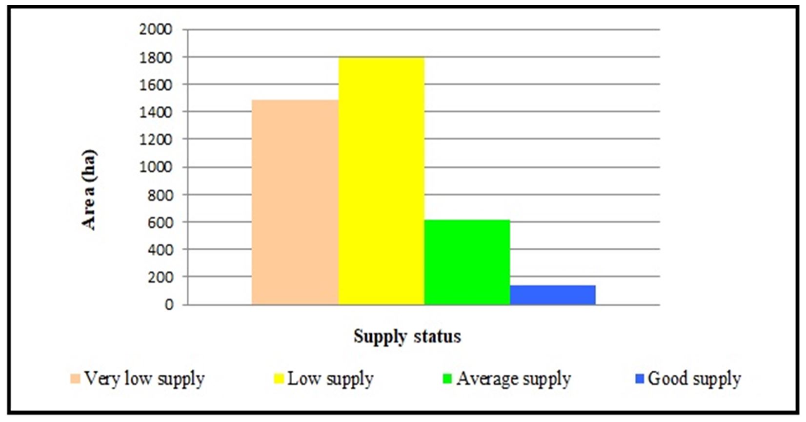
Figure 8 – The chart detailing the supply of soils with mobile phosphorus in the topsoil, according to Indicator 72
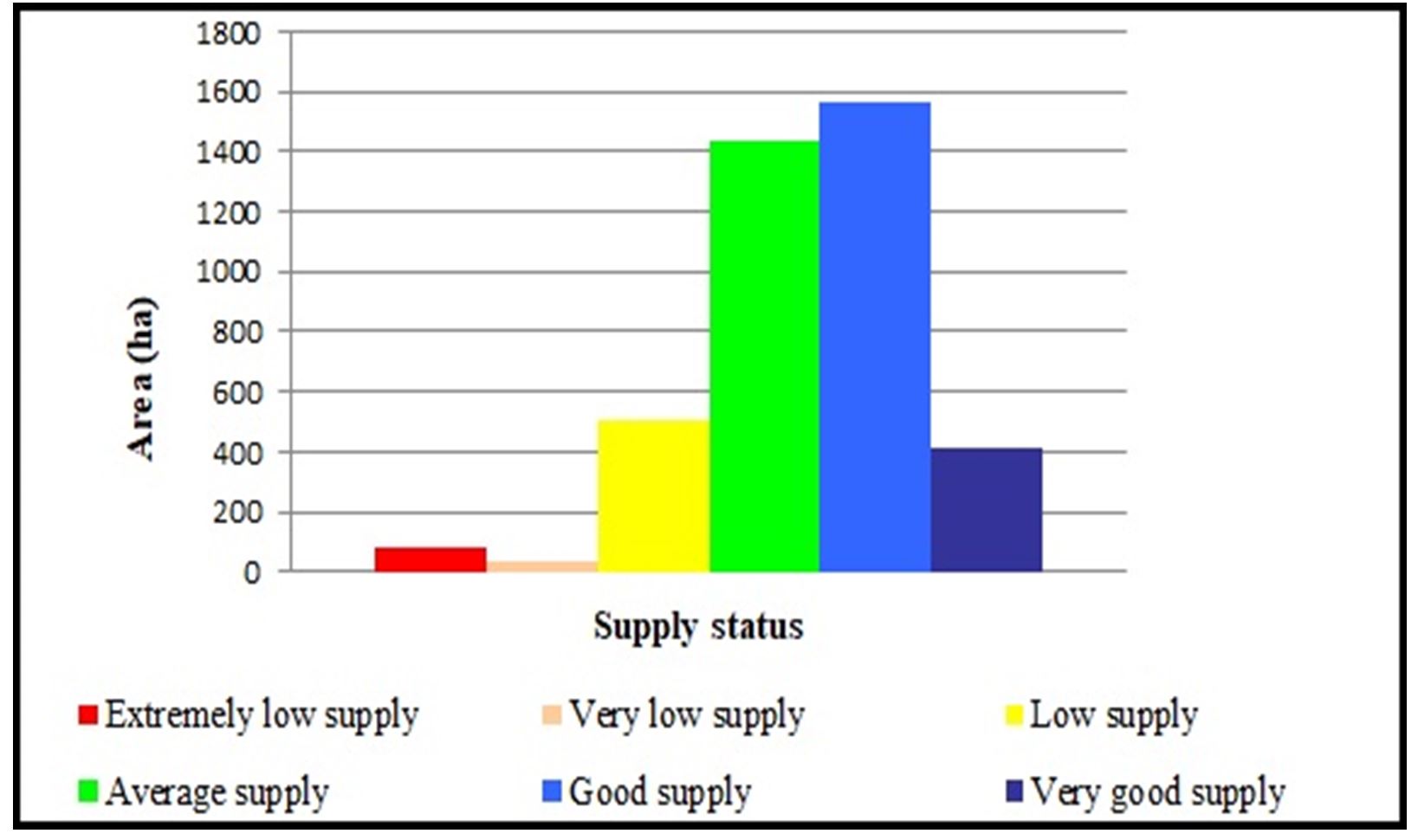
Figure 9 – The chart detailing the supply of soils with mobile potassium in the topsoil, according to Indicator 73
DISCUSSION
Regarding the researched area in the Raul Alb watershed, the weak alkaline pH soils in the topsoil is the dominant one, followed by the neutral reaction.
The alkaline pH of soils, influenced by the presence of CaCO3 it is a positive one because it improves their structure and determines a proper aero-hydric regime in the soil.
In the topsoil of the soils located in the upper hydrographic basin of the Raul Alb Creek, the low supply of humus is the most noticeable, and the average supply is found on surfaces 2 times smaller than that. The low humus supply, in the conditions of a fine texture in the first diagnostic horizons, determines, however, medium and high values of the humus reserve in the first 50 cm. The areas that form part of the researched area are located mainly on moderately and strongly inclined slopes, subject to the surface and deep erosion processes, which annually remove significant amounts of fertile material, reducing the productive potential of agricultural land.
Interpreting the humus content of the soils was made based on their texture in the first section of the soil profiles. The more clayey the soil, the higher the amount of humus must be to have a satisfactory supply of this element (Hassink, 1992; Aghilinategh et al., 2010).
In terms of the mapped area, medium-fine and fine textures are the most dominant and are found on an area encompassing 3 544.11 ha.
Calculating the humus reserve was made separately for each soil horizon, with the values obtained at the horizons encountered in the first 50 cm of the soil profile being added together. When interpreting this indicator, the texture of the soil in the 0–50 cm depth range was also taken into account, as well as how the land was used at the time of mapping.
In the researched area, the most fertile soils are rendzinic leptosol and phaeozem, which cover 909.60 ha and the molic subtype of eutric cambisol and regosol. These are the soils moderately affected by hydric erosion, amounting to 1,773.64 ha (43.97%) of the surface of the Raul Alb basin. Anthrosol is the least fertile of the soils present in the studied area (91.49ha), being also the most affected by hydric erosion (very strong and excessively eroded).
CONCLUSIONS
The soil cover in the Raul Alb watershed, up to the confluence with the Bărbuleţu Creek, as well as its fertility degree, is directly influenced by the relief and climatic conditions in which the soils that make it up are themselves formed and evolve.
By centralising the results obtained from the chemical analysis of soil samples taken from representative soil profiles, it was found that of the 4 034 ha surveyed, 59.42% have a weak alkaline pH at least in the topsoil due to the CaCO3 content. On an area of 520.68 ha, soils have a moderately acidic pH in the first soil horizon, requiring the correction of the reaction by applying calcareous alterations.
From the point of view of the supply with humus, an element that is interpreted based on the texture in the first part of the soil profile, the most significant share is the extremely poorly supplied soils with this element in the upper horizon, i.e., 73.42% of the mapped area (2961.95 ha). Only 1072.05 ha of the 4 034 of the area have an average humus content.
By applying the calculation formula, starting from the supply of humus in the first soil horizons, the humus reserve in the 0–50cm horizon resulted. According to this indicator, 2 116.31 ha (52.46%) of the total mapped area have a high to extremely high humus reserve, while 708.65 ha (17.57%) fall into the low reserve of humus.
On an area of 3544.11 ha, i.e. 87.85% of the surface of the researched hydrographic basin, the soils have a medium-fine and fine texture in the first soil horizon, while on an area of 489.89 ha (12.15%), the soils have an average texture.
Regarding the supply of soils with nitrogen from in the researched area, the values of the nitrogen index (I.N.) are a result of the calculation based on the humus content. Thus, 2 958.00 ha of the 4034 ha that were mapped are moderately and well supplied with nitrogen, that is 73.33%. The rest of the area (26.67%) has severe deficiencies in nitrogen content in the soil.
The situation is all the more serious in the case of supplying soils with mobile phosphorus, as they have a very small and small content of this element within the mapped area of 3280.27 ha, which is 81.31%. Only 3.54% (142.71 ha) of the researched area is well supplied with this element, which is a worrying factor.
In the case of the potassium supply, the soils in the upper part of the Raul Alb drainage basin are much better, with only 620.85 ha (15.39%) being extremely poorly supplied with this element and 84.61% of the total of 4034 ha researched having an average to very good concentration of potassium in the soil.
Thise researches can be the basis for the plan of anti-erosion measures to reduce the negative effects of soil degradation by erosion on agricultural uses. By establishing the degree of soil fertility, it is possible to propose fertilization and restoration works of the natural meadows included in the pastoral arrangements, of the privately owned orchards, and the strongly eroded, unproductive lands can be proposed for inclusion in afforestation improvement perimeters.
Acknowledgement. For their entirely professional collaboration during the period dedicated to structuring the database necessary to achieve the research, which will become a complex work concerning a 4 034 ha hydrographic basin, we are much obliged to our colleagues from ICPA Bucharest and OSPA Dambovita.
REFERENCES
Aghilinategh, N., Hemmat, A., Rezainejad, Y., Sadeghi, M. (2010). Effect of Long-term incorporation of organic manure on Physical and mechanical properties of a Silty Clay Loam Soil, Journal of Plant Production Science (Journal of Agricultural Researches), pag. 49-63.
Blair, N., Faulkner, R.D., Till, A.R., Poulton, P.R. (2006). Long-term management impacts on soil C, N, and physical fertility, Soil & Tillage Research 91, pag. 30-38, https://doi.org/10.1016/ j.still.2005.11.002.
Bucur, N., Lixandru, Gh. (1997). Fundamental principles of soil science. Soil formation, evolution, physics and chemistry (In Romanian), Dosoftei Publishing House, Iasi.
Ciocan, F., Manu, C.L., Matache, M.A., Petrescu, N., Muratoreanu, G. (2021). The use of GIS in the analysis of the morphodynamic potential in small hydrographic basins, in Subcarpathian areas. Case Study – Raul Alb, Dambovita County, Romania, 21th International Multidisciplinary Scientific Geo Conference, SGEM 2021, in press.
Hassik, J. (1992). Effects of soil texture and structure on carbon and nitrogen mineralization in grassland soils, Biology and Fertility of Soils, 14:126-134, The Netherlands.
Florea, N., Balaceanu, V., Rauta, C., Canarache, A. (1987). Methodology for the Development of Pedological Studies, Part III, (In Romanian), Oltenia Publishing House, Craiova.
Gilmour, J.T. (2020). Predicting soil organic matter nitrogen mineralization, Soil Science Society of America Journal, 85 (2), https://doi.org/10.1002/ saj2.20203, pag. 353-360.
Jones, R.J.A., Hiederer, R., Rusco, E., Montanarella, L. (2005). Estimating organic carbon in the soils of Europe for policy support. European Journal of Soil Science. Volume 56, Issue 5, https://doi.org/10.1111/j.1365-2389.2005.00728.x pag. 655 – 671.
Rolando, J.L., Dubeux, J.C.B., Ramirez, D.A., Moreno, M.R., Turin, Cecilia, Mares, V., Sollenberger, L.E., Quiroz, R. (2018). Land use effects on soil fertility and nutrient cycling in the Peruvian high-andean puna grasslands, Soil Science Society of America Journal, 82 (2), pag. 463-474 https://doi.org/10.2136/sssaj2017.09.0309.
Sevastel, M., Petrescu, N., Augustina, Tronac (2015). Some aspect concerning gully erosion process in small torrential watersheds and its impact on environment, Carpathian Journal of Earth and Environmental Sciences, May 2015, Vol.10, No.2, ISSN Printed: 1842-4090, pg. 115-122, WOS: 000387504900012.
Vlad, V., Florea, N., Toti, M., Mocanu, V. (2014). Correlation of soil classification system SRCS and SRTS. SRTS+ System, (In Romanian), Sitech Publishing House, Craiova.
Ciocan Florin, Manu Catalin, Matache Alexandru, Muratoreanu George, Petrescu Nicolae

