Lawrence Damnyag, Francis Tease, Alex Aboagye Bampoh, Jewel Andoh
ABSTRACT. Deforestation in Ghana is primarily caused by agriculture, and as such, there is a need to explore agricultural systems that promote forest and environmental conservation. Studies on decision support frameworks that can help farmers and landowners make informed optimal land use choices are limited in the country. This study attempts to fill the gap. We used survey questionnaire and focus group discussion to gather data from farmers and other stakeholders. Multi-Criteria Decision Analysis (MCDA) technique was employed to analyse the data. The results showed that agroforestry, with the highest ranking (probability of 0.98), is the optimal land use option. Coconut and oil palm land use options were perceived to be contributing to the degradation of the periphery of the Ankasa Conservation Area (ACA). Intensifying education and training will increase the uptake of agroforestry as an integrated multifunctional land use strategy in the ACA.
Keywords: agriculture; agroforestry; decision support system; Ghana; protected area.
Cite
ALSE and ACS Style
Damnyag, L.; Tease, F.; Bampoh, A.A.; Andoh, J. Application of Multi-Criteria Decision Analysis to support land use decision-making in Ankasa Conservation Area, Ghana. Journal of Applied Life Sciences and Environment 2023, 56 (3), 345-364.
https://doi.org/10.46909/alse-563104
AMA Style
Damnyag L, Tease F, Bampoh AA, Andoh J. Application of Multi-Criteria Decision Analysis to support land use decision-making in Ankasa Conservation Area, Ghana. Journal of Applied Life Sciences and Environment. 2023; 56 (3): 345-364.
https://doi.org/10.46909/alse-563104
Chicago/Turabian Style
Damnyag, Lawrence, Francis Tease, Alex Aboagye Bampoh, and Jewel Andoh. 2023. “Application of Multi-Criteria Decision Analysis to support land use decision-making in Ankasa Conservation Area, Ghana” Journal of Applied Life Sciences and Environment 56, no. 3: 345-364.
https://doi.org/10.46909/alse-563104
View full article (HTML)
Application of Multi-Criteria Decision Analysis to Support Land Use Decision-Making in Ankasa Conservation Area, Ghana
Lawrence DAMNYAG1, Francis TEASE1, Alex Aboagye BAMPOH2* and Jewel ANDOH1
1CSIR-Forestry Research Institute of Ghana, P. O. Box UP63, Kumasi, Ghana; e-mail: ldamnyag@yahoo.com; francistease@gmail.com; andohjewel@gmail.com
2Tropenbos Ghana, P. O. Box UP982, KNUST, Kumasi, Ghana
*Correspondence: aabampoh@yahoo.com
Received: Aug. 17, 2023. Revised: Sep. 14, 2023. Accepted: Sep. 19, 2023. Published online: Oct. 19, 2023
ABSTRACT. Deforestation in Ghana is primarily caused by agriculture, and as such, there is a need to explore agricultural systems that promote forest and environmental conservation. Studies on decision support frameworks that can help farmers and landowners make informed optimal land use choices are limited in the country. This study attempts to fill the gap. We used survey questionnaire and focus group discussion to gather data from farmers and other stakeholders. Multi-Criteria Decision Analysis (MCDA) technique was employed to analyse the data. The results showed that agroforestry, with the highest ranking (probability of 0.98), is the optimal land use option. Coconut and oil palm land use options were perceived to be contributing to the degradation of the periphery of the Ankasa Conservation Area (ACA). Intensifying education and training will increase the uptake of agroforestry as an integrated multifunctional land use strategy in the ACA.
Keywords: agriculture; agroforestry; decision support system; Ghana; protected area.
INTRODUCTION
Concerns about global climate change and biodiversity loss have intensified efforts to manage forests for multiple ecosystem services (Waring et al., 2020). Efforts to address climate change have primarily centred around decreasing the amount of greenhouse gas (GHG) emissions. Research indicates that tropical deforestation and forest degradation (DFD) were responsible for emitting 1-2 billion tonnes of carbon annually during the 1990s, which equated to 15-25% of worldwide annual carbon dioxide (CO2) emissions (Houghton, 2005). Reducing GHG emissions caused by DFD is essential in the global effort to mitigate climate change (Angelsen et al., 2012). Good forest management means ensuring that the forest is a net carbon store (Birdsey et al., 2006). Forest management practices, therefore, play a crucial role in reducing the global climate change effects resulting from the increase in CO2 concentrations in the atmosphere.
At the regional level, agriculture is the cause of the majority of deforestation in Africa, Latin America, and Asia (Andoh et al., 2022). In South America, in the 1980s and 1990s, the area of cattle pastures increased by 35 million acres, and in the same period, the area of cropland increased by 5 million acres, most of which had been forests, but were cleared for other land use (Boucher et al., 2011). In Asia, large-scale agriculture (for example, palm oil, rubber, and coconut) and timber plantations drive most deforestation. In the 1990s, palm oil alone accounted for 80% of Asia’s plantation expansion and is the main economic crop in Malaysia and Indonesia (Boucher et al., 2011).
The expansion of palm oil plantations has significantly impacted the habitat of orangutans and other biological species in Malaysia and Indonesia (Abram et al., 2015; Goggin and Murphy, 2020). In Africa, large commercial agriculture has not contributed to deforestation to the same extent as in other regions, due to the smaller scale of agricultural production (Boucher et al., 2011). This situation could change with the growth of foreign investment in commercial agriculture in Africa and the increase in the demand for products in other regions that have led to deforestation.
In the early 1990s, Ghana lost more than 33.7% of its forest area (FAO, 2010). Between 2005 and 2010, the annual deforestation rate was estimated at 2.19%, making it the sixth highest in the world during the same period (FAO, 2010). Ghana’s REDD+ Readiness Preparation Proposal (R-PP) points out that the causes of deforestation in the country are related to economic, demographic, institutional, and policy factors, and activities such as small-scale agriculture, wood harvesting, land conversion, and mining are the main drivers (FC, 2022).
Ghana has 21 Protected Areas (PAs) covering over 1.3 million ha (5.6%) of its land mass (UICN/PACO, 2010). The PAs have above-ground biomass of about 275-400 Mg/ha, higher than the 125-225 Mg/ha in non-PAs (MLNR, 2012). Although PAs have the potential to capture significant amounts of carbon, they are under threat due to rising levels of deforestation and forest degradation (DFD) in and around them. These threats include poaching (illegal gathering of wild plants and animals) and farming (Förster, 2009; UICN/PACO, 2010). The Ankasa Conservation Area (ACA), one of the PAs, is a biological hotspot and is considered as one of the most biologically diverse forest ecosystems in the country (Förster, 2009). Efforts made to reinforce the protection of these PAs include the establishment of community collaborative units such as the Community Development Unit (CDU), PA Management Advisory Units (PAMAUs), PA Management Advisory Board (PAMAB), and Community Resource Management Areas (CREMAs) to improve communication between locals and PA officers. Additionally, the Wildlife Division of the Forestry Commission of Ghana has established law enforcement units, patrol units, and camps for PA officers (Ayivor et al., 2020).
Over-exploitation of the ACA’s periphery by forest-dependent communities for unsustainable shifting cultivation and cash crop farming is causing DFD, thereby decreasing the quality of environmental services and increasing the emission of greenhouse gases (Damnyag et al., 2023).
The continued DFD of the periphery poses a threat to the conservation area itself. This is because when the off-reserve area fails to provide the local communities with the needed forest resources, they will invariably encroach on the reserve and thus reduce the ability of the ACA to serve as a carbon sink. There is therefore the need for research that will provide farmers and other stakeholders in the conservation area with information to enable them to make informed optimal land use decisions particularly, in the off-reserve area. Making informed decisions involves trade-offs between the farmers’ or forest stakeholders’ various conflicting objectives (ITTO, 2010).
This study aims to develop a decision support system for farmers, landowners, forest managers, agricultural extension officers, and traditional authorities to enhance the sustainable management of the ACA periphery which has been earmarked as one of Ghana’s emission reduction programme areas. Specifically, this study seeks to determine the land use type that has the greatest potential to lower emissions (control DFD) in the ACA and secondly, to determine the land use type that enhances well-being values (livelihoods and ecosystem services).
Theoretical framework
Multi-Criteria Decision Analysis technique is used to select the best alternative, classify alternatives, or rank alternatives in order of preference (Damnyag et al., 2013; Mardani et al., 2015). A number of authors have used different MCDA methods to make decisions in environmental management (Khalili and Duecker, 2013), forest management (Mendoza and Prabhu, 2000), protection of natural areas (Wolfslehner and Seidl, 2010), biodiversity conservation planning (Geneletti and van Duren, 2008), water management (Moffett and Sarkar, 2006), wetland management (Hajkowicz and Collins, 2007), and agricultural resource and farm management (Herath, 2004). More than 100 MCDA methods have been used in practice, including the original, derived, and combined methods.
For example, Saaty and Ergu (2015) used Case-Based Reasoning (CBR) to solve the task of forecasting the risk of wildfires. Bentes et al. (2012) used an integrated Geographic Information System and Fuzzy Analytic Hierarchy Process (FAHP) approach to evaluate land suitability for sugarcane cultivation. Alvarez-Guerra et al. (2009) applied four different MCDA methods, including Weighted Summation, ELECTRE II, Evamix, and Regime, to prioritize sites for sediment management in the Bay of Santander in Spain.
The MCDA framework offers a structured process to design, evaluate, and select decision alternatives when faced with conflicting and incommensurate criteria (Jamil et al., 2018; Linkov et al., 2006). The MCDA method takes into account both quantitative and qualitative information, making it a useful tool to complement or replace cost-benefit analysis. It involves steps that encourage teams to discuss the problem they are facing and consider the values that each team member deems important. The team also discusses alternative courses of action and how they interact with each other, as they work together iteratively to find the best solution.
The process includes: i) Identification of objective(s) and relevant stakeholders: The objective(s) should be specific, measurable, agreed upon, realistic, and time-sensitive; ii) Identification of stakeholder interests: This is crucial for determining which criteria to analyse and evaluate for each decision. The interests must be measurable and contribute to achieving the objective; iii) Rating the alternatives: In the third step, the research must rate each course of action in terms of how it satisfies each criterion. This step requires expert consultation; iv) Weighting stakeholder interests: Each stakeholder must assign weights to the different criteria according to their personal preference.
To encourage discussion among the group, the individual weightings are not combined or averaged with those of others. Weighting is essential because it helps to determine the relative significance of each criterion in the overall decision-making process; v) Scoring the alternatives: Individuals multiply their weights by corresponding criterion rating values. The sum of scores determines the most preferable course of action; vi) Discussion: Lastly, stakeholders compare their scores to see if a clear and preferred course of action has emerged (Mardani et al., 2015). If that is the situation, the team may proceed with making a decision.
The aspect of MCDA applied in this study is the Regime method. The Regime method is a discrete multiple evaluation approach appropriate for analysing both qualitative and quantitative data in a research project and policy evaluation. It establishes ranking relationships among options and uses pairwise comparisons to assess how well each alternative performs (Yuan et al., 2022). The influence matrix and a set of weights serve as the foundation for the method’s structure. The Regime method belongs to the outranking approaches. The outranking methods build a preference relation among alternatives evaluated on several criteria (Yuan et al., 2022).
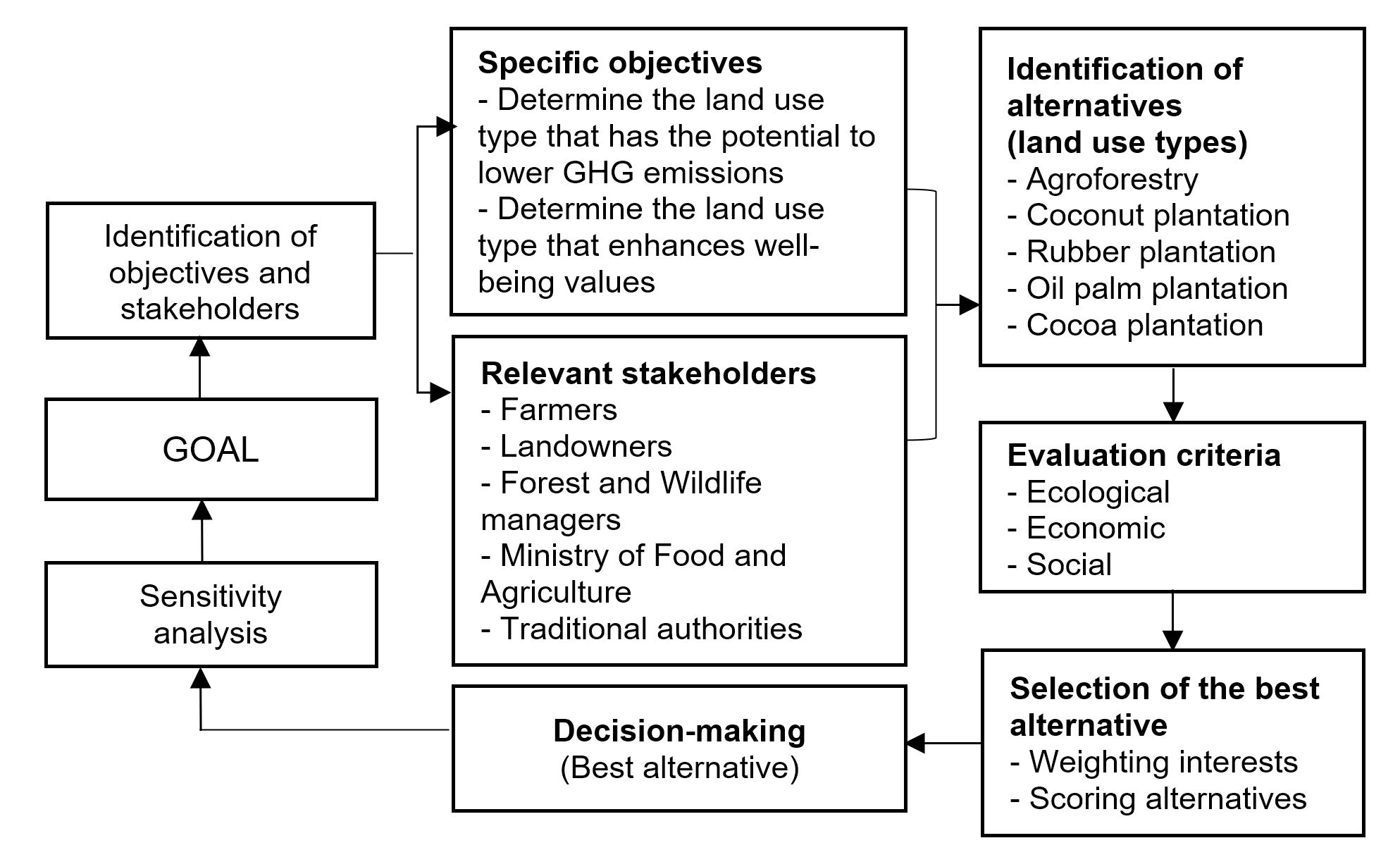
There are limited studies applying MCDA to support decision-making on land use types that can help reduce deforestation and forest degradation and protect the periphery of the ACA in Ghana. This study uses the MCDA technique to identify the land use type that can lower greenhouse gas emissions and enhance the well-being of local communities (Figure 1). The land use type was evaluated using ecological, economic, and social criteria.
MATERIALS AND METHODS
Study area
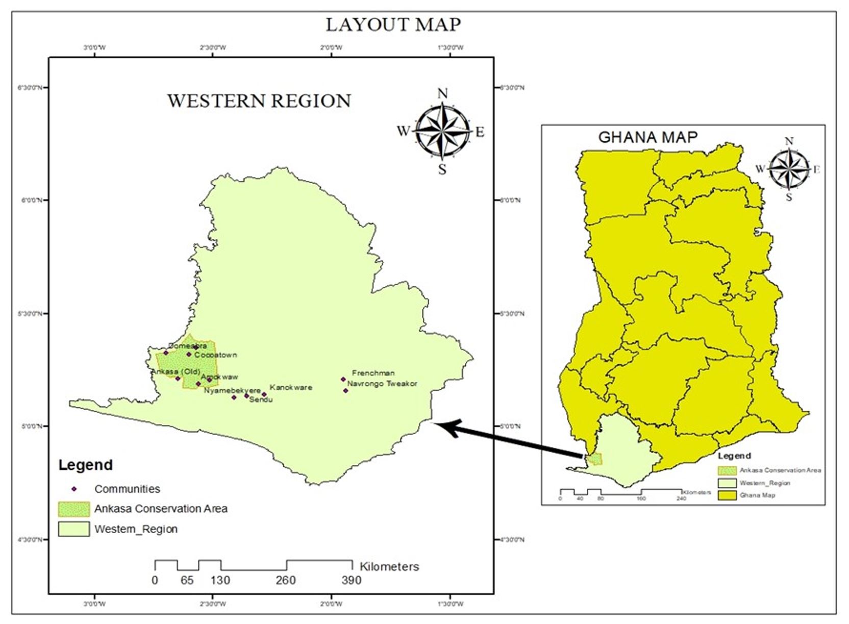
The study was carried out in communities located adjacent to the Nini-Suhien National Park and the Ankasa Game Production Area, known as the Ankasa Conservation Area (ACA) (Figure 2).
The ACA is located in southwestern Ghana and spans Jomoro, Ellembelle, and Wassa Amenfi West administrative districts. It covers a land area of 50,000 ha and is a wet evergreen forest of the Upper Guinea forest belt (UICN/PACO, 2010). The mean annual rainfall of the area ranges between 2000-2200 mm. Local communities around the ACA have been organized into Community Resource Management Areas (CREMAs) (Braimah et al., 2009). CREMAs are community-based participatory management groups that provide support for natural resource conservation. They are easier to work with because of their well-organized structure.
Four CREMAs were purposively selected for the study based on accessibility and closeness (0.5–7 km) to the ACA. The CREMAs and communities selected for the study were Nyamebekyrere, Sendu, and Kanokware (Aiyinase Ayawora CREMA); Frenchman, Faya, Amokwaw, and Old Ankasa (Amokwaw CREMA); Navorongo (Tweakor CREMA); Fawoman, Cocoa Town, and Domeabra (Ghana Nungua-Cocoa Town CREMA). The study communities are made up of both indigenes and migrants. The ACA and surrounding communities fall within the Emission Reduction Programme (ERP) area for Ghana’s REDD+.
Data collection and Multi-Criteria Decision Analysis (MCDA) procedure
Primary and secondary data were collected for the study. In the study area, a reconnaissance survey was conducted to present the research and discuss the research objectives with key stakeholders including ACA management, the Ministry of Food and Agriculture (MoFA) of Tarkwa Nsuaem, Jomoro, and Ellembele. The Forest Services Division (FSD) office at Tarkwa was also visited because the ACA falls under their jurisdiction. Discussions were also held with local chiefs and CREMA executives. The primary data for the study were collected using a semi-structured questionnaire and focus group discussion (FGD). The FGD participants provided weights for the main effects in the effects table. Published and unpublished literature on the ACA was consulted to enrich the study.
Application of MCDA in the study
As described in Figure 1, the study followed several essential MCDA steps such as:
- Stakeholder identification and classification
- Description of land use types
- Specification of evaluation criteria
- Sensitivity analysis
Stakeholder identification and classification
Stakeholder groups were identified and categorized as either primary or secondary, based on their connection to the conservation area. Farmers, landowners (any person or group of people that have the reserved right (legally or customary) to use, convey, lease, or assign a parcel of land), and traditional authorities (also called chiefs – act as custodians of the land and are mandated by the locally prevailing customs and traditions to make decisions on behalf of their subjects) were categorized as the primary stakeholders. The secondary stakeholders were the management of ACA (mandated to protect and manage wildlife and other globally significant biodiversity resources in the protected area), FSD of the Forestry Commission (mandated to protect, sustainably manage, and develop forest resources), and MoFA (government agency responsible for developing and executing policies and strategies for the growth of agriculture).
Description of land use types
The land use types identified in the ACA periphery include:
- Coconut plantation: Coconut plantations on a commercial scale (monoculture)
- Oil palm plantation: Oil palm plantation on a commercial scale (monoculture)
- Cocoa plantation: Cocoa plantation on a commercial scale (fewer to zero timber tree species are integrated into the system)
- Rubber plantation: Rubber plantation on a commercial scale (monoculture)
- Agroforestry (food or cash crops (e.g., cocoa) inter-planted with timber tree species)
Specification of evaluation criteria
Three criteria (ecological, economic, and social) were used to evaluate the strengths and weaknesses of the land use options.
Relying on Kokwe (2012), the indicators for ecological criteria in the context of the study were defined as land use type contribution to deforestation and forest degradation control, enhancement of carbon stocks, contribution to forest ecosystem health and vitality, soil and water resources protection, and biodiversity conservation in the ACA.
The indicator for the economic criteria was defined as the potential contribution (as well as the economic cost/opportunity cost) of the land use type to the local and national gross domestic product.
The indicator for social criteria was defined as the contribution of land use to the preservation or improvement of the social, cultural, and spiritual well-being of forest-dependent communities. For each of these criteria, a number of sub-effects were identified. Stakeholders selected the sub-effects based on their knowledge of the land use types and provided quantitative and qualitative scores as inputs for each of the sub-effects.
Sensitivity analysis
To ensure the reliability of the evaluation of land use types, a sensitivity analysis was conducted. In this study, the scoring of most of the effects was done from both expert and non-expert judgements and not from any existing quantitative data.
Therefore, a higher margin of error (10%) was assumed to account for potential inaccuracies. If the margin of error exceeds 10%, the evaluation results for the land use types are considered not dependable.
Data analysis
We analysed the collected data using Multi-Criteria Decision Analysis DEFINITE 3.1 and the Statistical Package for the Social Sciences (SPSS) version 16. A multi-criteria technique within the DEFINITE-regime method, which falls under the outranking approach was used to analyse the set of discrete alternatives in the periphery of the ACA. Instead of using the Weighted Summation Method (WSM), we used the Regime method for the evaluation because the scores obtained were both qualitative and quantitative. The outranking method is one of the most effective approaches in MCDA (Kangas et al., 2001). The method uses weights to denote the importance of certain criteria over others. An option is considered to outrank another if it performs better on enough important criteria and is not significantly inferior on any one criterion. A sensitivity analysis was carried out to ensure that the outcomes of the land use evaluation were reliable. In this case, we assigned a 10% uncertainty, which is the maximum percentage for which we expect the scores to differ from the values in the effect table. For example, if we consider a sub-effect score of 30, our 10% uncertainty indicates that we are very confident, i.e., 99% certain, the score is between 27-33. The procedure included in the DEFINITE software package generates a probability table that consists of the alternatives (row) and positions (column). Each table entry represents the probability that an alternative will receive a certain rank number given the uncertainty of 10% on the effects scores. The last column of the table contains the weighted sum (total scores) of the probabilities of all rank numbers of the alternatives. The total score indicates the stability of the ranking of the alternatives (Alvarez-Guerra et al., 2009; Janssen and van Herwijnen, 2006).
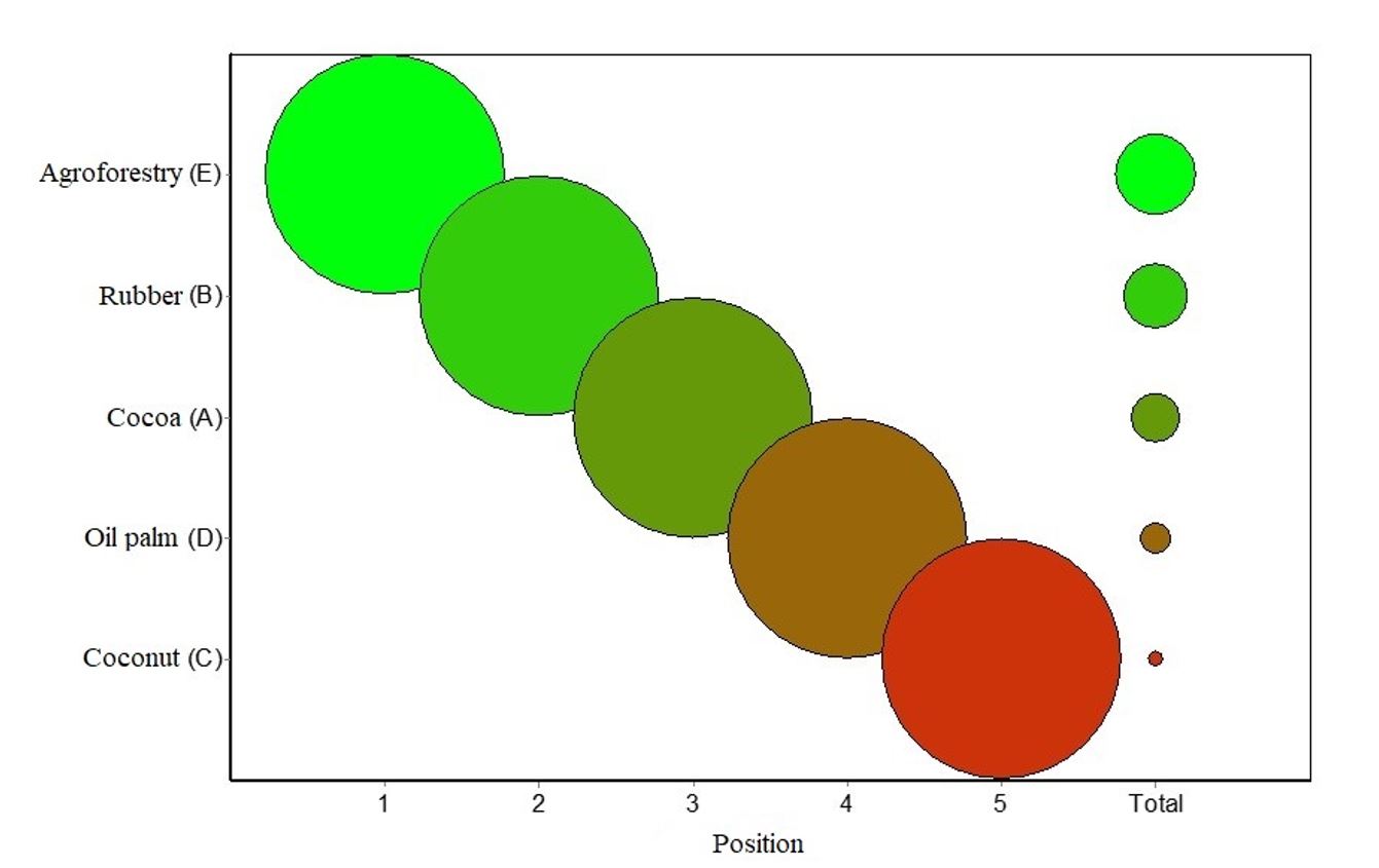
For example, if the difference in the weighted sum of two alternatives exceeds 0.2 (which is set arbitrarily), the rank order of both options is considered to be sufficiently certain (Janssen and van Herwijnen, 2006). In this study, the probability table is represented graphically with circles using the values from the probability table (diagonal probability values and the total scores in the last column). The alternatives are indicated on the vertical axis of the graph and their positions (1st, 2nd, 3rd, …) on the horizontal axis.
RESULTS
Characteristics of respondents
Table 1 presents the study participants’ background information. The majority (71.4%) of the respondents were males and the largest number of respondents (33.3%) were within the 40-49 age bracket. Regarding education, most of the respondents had some form of formal education.
Existing land use types in ACA periphery
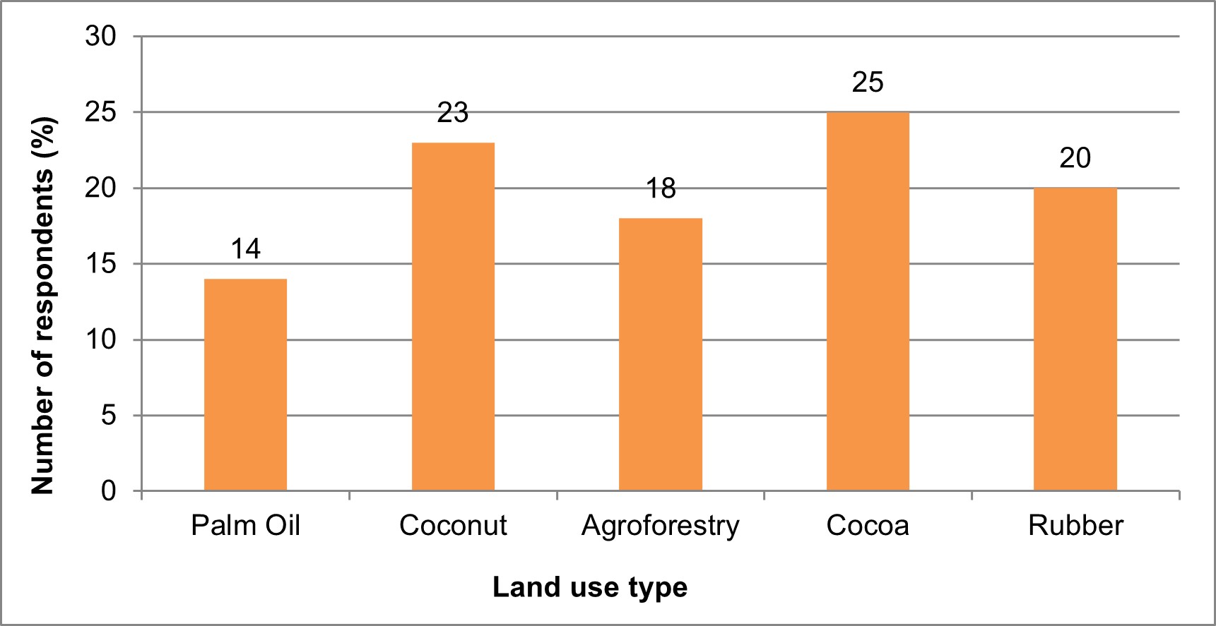
Five major land use types were identified in the periphery of the ACA. Cocoa plantation (25%) was the dominant land use type and was followed by coconut plantation (23%) and rubber plantation (20%). Oil palm plantation was the least mentioned land use type, accounting for only 14% of the responses (Figure 3).
Benefits derived from land use types
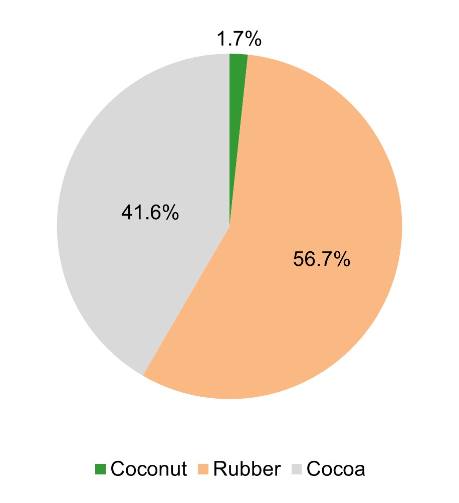
Study participants indicated the land use types which generate the highest monetary benefit. From Figure 4, respondents associated high monetary benefit to three out of the five identified land use types in the periphery of ACA. From the responses, rubber (56.7%) and cocoa (41.6%) plantations generate high monetary benefits (Figure 4). Regarding the non-monetary benefits of the identified land uses, respondents indicated that agroforestry (79.4%) generates the highest non-monetary benefit. Oil palm (1.7%) generates the least non-monetary benefit (Figure 5). Respondents further indicated the direct and indirect benefits derived from the various land use types. Table 2 summarizes the responses.
Table 1
Characteristics of respondents
|
Variable |
Category |
Frequency |
Percent (%) |
|
Age |
< 29yrs |
3 |
4.8 |
|
30-39yrs |
14 |
22.2 |
|
|
40-49yrs |
21 |
33.3 |
|
|
50-59yrs |
15 |
23.8 |
|
|
> 60yrs |
10 |
15.9 |
|
|
Total |
63 |
100 |
|
|
Sex |
Male |
45 |
71.4 |
|
Female |
18 |
28.6 |
|
|
Total |
63 |
100 |
|
|
Education |
None |
14 |
22.3 |
|
Primary |
15 |
23.8 |
|
|
Junior High |
29 |
46.0 |
|
|
Senior High |
5 |
7.9 |
|
|
Total |
63 |
100 |
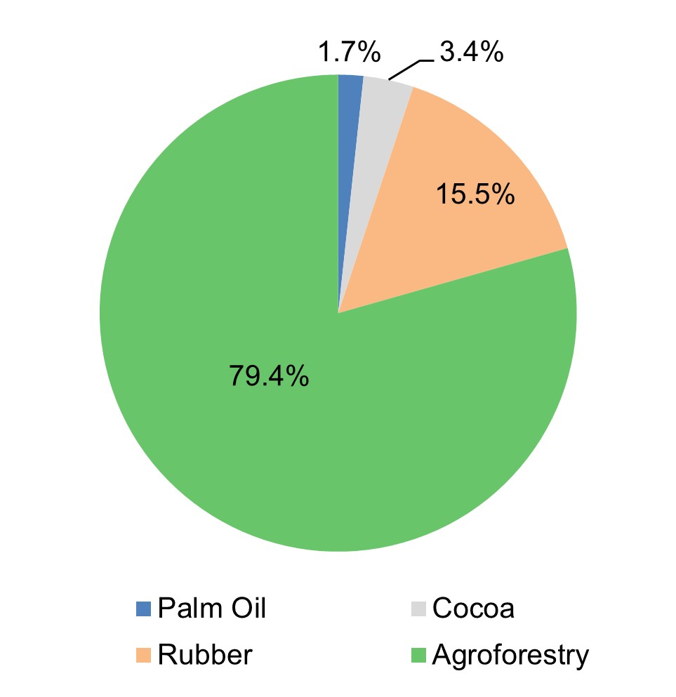
Figure 5 – Respondents’ views on non-monetary benefits from the various land use types
Table 2
Direct and indirect benefits associated with land use types in ACA periphery
|
Land use type |
Direct benefit |
Indirect benefit |
|
Rubber plantation |
· Snails · Mushrooms · Source of game |
· Erosion control · Watershed protection · Micro-climate regulation · Soil fertility improvement · Rainfall enhancement |
|
Coconut plantation |
· Fuelwood · Husk for making doormats · Brooms · Indigenous roofing material |
· Windbreak · Shade |
|
Cocoa farm |
· Pods for soap making · Roots for medicinal use · Source of game |
· Protection of watershed · Erosion control · Micro-climate regulation · Soil fertility improvement · Rainfall enhancement |
|
Agroforestry |
· Fuelwood · Lumber · Sticks for building · Source of game · Source of medicinal plants |
· Rainfall enhancement · Soil fertility improvement · Micro-climate regulation · Carbon storage |
|
Oil palm plantation |
· Brooms · Fuelwood · Source of mushrooms · Source of game |
· Shade · Micro-climate regulation |
Perception of land use types that degrade ACA periphery
Respondents were asked to indicate the land uses that degrade the periphery of the ACA the most. The responses obtained showed that coconut plantation (45.2%) and oil palm (38.5%) were the leading land uses driving changes in the ACA periphery (Figure 6).
Perception of land uses that can help control DFD in ACA
Respondents were asked to indicate the land use options that have the potential to control DFD in ACA. About 52% of the respondents mentioned rubber plantations as the land use type with the highest prospect to control DFD. Cocoa which represents the ‘economic lifeline’ of the people was adjudged as the land use type that contributes little to DFD control (Table 3).
Multi-Criteria Decision Analysis
Weighting effects and sub-effects in the evaluation of land use types
The weight setting for the effects was carried out in collaboration with stakeholders, considering the relative importance of each effect on the study’s objective. The weightings are divided into two levels, level 1 for main effects and level 2 for sub-effects (Table 4). The level 1 weighting was done by evaluating the relative importance of the main effects to the study’s objective (helping farmers and landowners make informed decisions on the land use type that can help control DFD and enhance well-being values). Stakeholders prioritized ecological effect which was assigned weight 1 (i.e., ranked 1, as the most important). Economic effect was ranked second (weight 2, rank 2), followed by social effect (weight 3, rank 3). For level 2 weighting, the importance of various sub-effects to the main effects and objectives of the study was considered. For instance, in the ecological sub-effects, priority was given to reducing carbon emissions and enhancing carbon stocks.
Figure 7 shows the overall outcome of the MCDA taking into consideration the ecological, economic, and social effects. Agroforestry recorded the highest probability (0.98), emerging as the most important or optimal land use for controlling DFD, carbon emission reduction, and enhancing well-being values. Rubber plantation (0.76) and cocoa plantation (0.52) were the second and third optimal land use options respectively (Figure 7).
Sensitivity analysis of the land use types evaluation
The colour codes reinforce the positions recorded in the ranking of the land use types. The land use type ranked in the first position is depicted in bright green while the land use type ranked in the last position is depicted in red (Figure 8). The size of the circles corresponds to the likelihood of each land use type being ranked in a particular position. The difference in size between any two of the smaller-sized circles arranged vertically in Figure 8 is more than 0.2.
From Figure 8, agroforestry remained in the first position (1), as a priority for farmers, landowners, and other stakeholders in the ACA. The positions of the other land use categories remained unchanged as shown in the ranking outcome of Figure 7. In the case of 10% uncertainty, the large-sized circles on the main diagonal of the chart demonstrate that, even if the scores differed by up to 10% from the assigned values, the order of the land use types will hardly vary. The sensitivity analysis gave stability to the ranking results in Figure 7, that is, it reiterated the choice of agroforestry as the optimal land use option to tackle deforestation and forest degradation and improve well-being values (livelihoods and ecosystem services) in the ACA.
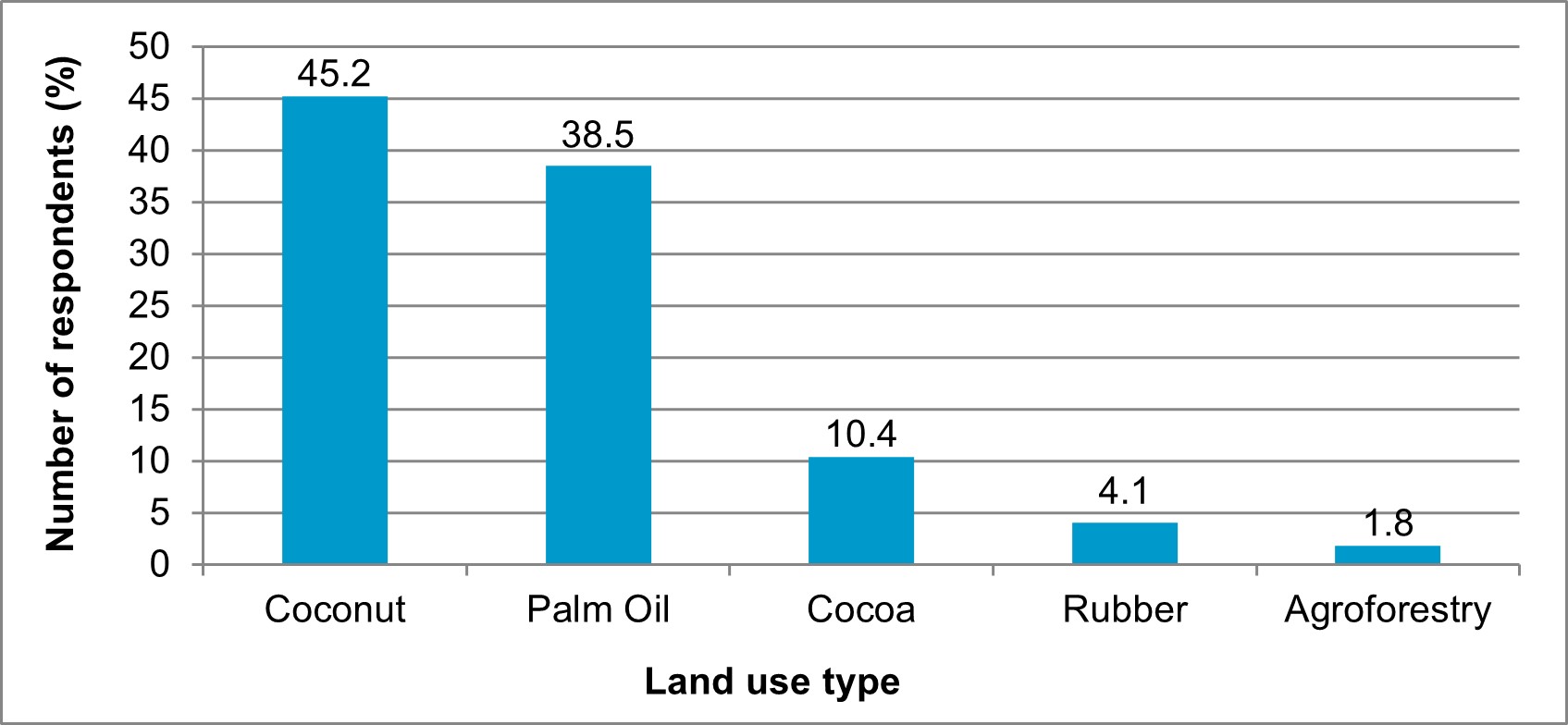
Figure 6 – Respondents’ views on land use type contribution to the degradation of the periphery of ACA
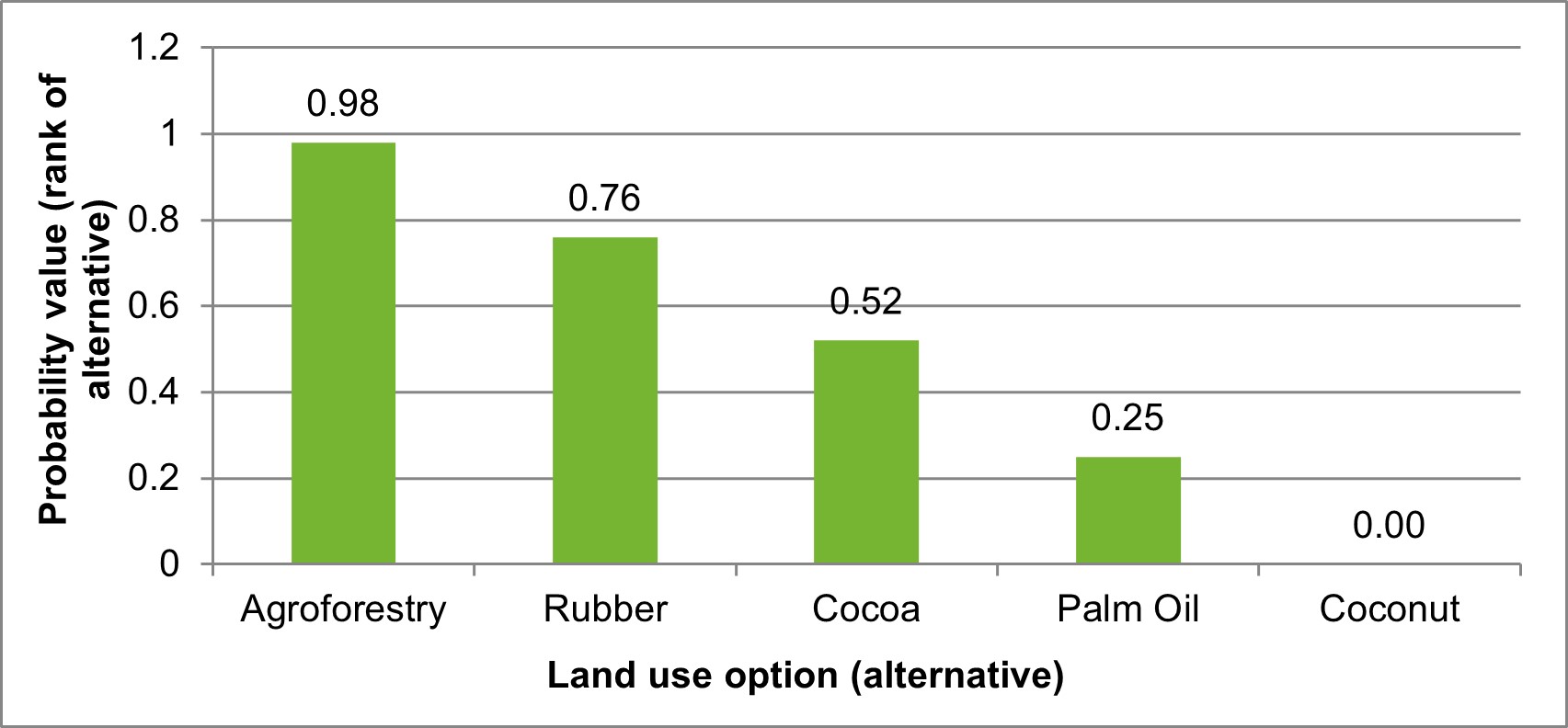
Figure 7 – Ranking of land use types in ACA from MCDA
Table 3
Respondents’ views on land use types that can contribute to DFD control in ACA
|
Land use type |
Frequency |
Percent (%) |
|
Cocoa plantation |
3 |
5.4 |
|
Rubber plantation |
29 |
51.7 |
|
Agroforestry |
24 |
42.9 |
|
Total |
56 |
100 |
Table 4
Effects, sub-effects and their weighting in the evaluation process of land use types in the ACA periphery
|
Effects and sub-effects |
Weight level 1 |
Weight level 2 |
|
Ecological |
1 |
|
|
Reduce carbon emissions and enhance carbon stock |
|
1 |
|
Carbon sequestration |
|
2 |
|
Rainfall enhancement |
|
3 |
|
Micro-climate regulation |
|
4 |
|
Biodiversity enhancement |
|
5 |
|
Plant and animal habitat |
|
6 |
|
Soil conservation |
|
7 |
|
Protection of water catchment areas |
|
8 |
|
Economic |
2 |
|
|
Individual economic benefit |
|
1 |
|
National economic benefit |
|
2 |
|
Social capital |
|
6 |
|
Human capital |
|
5 |
|
Physical capital |
|
4 |
|
Financial capital |
|
3 |
|
Natural capital |
|
7 |
|
Employment creation |
|
8 |
|
Social |
3 |
|
|
Status symbol |
|
1 |
|
Cultural significance |
|
2 |
|
Spiritual benefit |
|
3 |
DISCUSSION
Existing land use types in the periphery of the ACA
Over the years, commodity agriculture (e.g., cocoa farming, oil palm, and rubber) has subjected Ghana’s high forest zones to unprecedented changes (Damnyag et al., 2023; Noponen et al., 2014). The dominant land use type in the periphery of ACA is cocoa plantation. ITTO (2010) indicated that the ACA is a preferred destination for farmers engaged in cocoa cultivation.
Often produced on a smallholder basis, the cocoa cash crop is mainly cultivated in the high and semi-deciduous forest agroecological zones in Ghana. Cocoa farms benefit from forest ecosystem structure, functions, services, and processes (Bampoh and Damnyag, 2020).
Coconut plantation was ranked second in terms of land use dominance. The ACA spans the Jomoro, Ellembelle, and Wassa Amenfi West administrative districts that are typically noted for coconut cultivation. Aside from contributing to the local and national economy, coconut production provides direct and indirect use values to farm households. Coconut husks are used in producing doormats and can also be used as firewood, the leaves are used as roofing material for houses and for making brooms. The plethora of benefits from coconut plantations have contributed to their expansion in the periphery of the ACA and the Western Region of Ghana (Campbell, 2006).
Despite the ACA being an emission reduction programme area, agroforestry land use was not popular in the study communities. Several factors may have accounted for the low agroforestry practice in the area. The longstanding issue of tree tenure, lumber theft, destruction of farms during tree felling operations, and weak enforcement of forest laws and regulations have often hampered agroforestry transition (Damnyag et al., 2013). The implementation of the Ghana Cocoa-Forest REDD+ Programme, an emission reduction programme which has entered a result-based payment phase, can help promote agroforestry adoption in the ACA (Andoh et al., 2022).
Benefits derived from identified land use types
Many land use decisions are made based on expected economic value. In this study, only three (rubber, coconut, and cocoa) out of the five land use types identified were found to produce high monetary benefit. Rubber plantations emerged as the land use type that generates the highest monetary benefit. In the Western region of Ghana, rubber cultivation is a lucrative venture that has attracted government and private sector investment. The increase in the price of rubber and the profitability of the venture has led to the commercial expansion of rubber plantations, to the extent that lands used to cultivate cocoa are being cleared to make way for rubber plantations (Koomson et al., 2022; Gakpo, 2018).
The study respondents were of the view that agroforestry land use provides the highest non-monetary benefit (those that are not measured in terms of monetary units or traded on the traditional market). Evidence for the impacts of agroforestry on ecosystem service provision are well documented (Castle et al., 2022). The predominant land use in the ACA periphery is cocoa production which depends on forest ecosystem services. Smallholder farmers recognize the impact of regulating, provisioning, and supporting services on agricultural productivity (Bani and Damnyag, 2017). A decline in the production of these ecosystem services impacts crop yield and, in most cases, cost has to be incurred in replacing these services (Bampoh and Damnyag, 2020). The study respondents derive direct and indirect use values from the identified land use types. These values contribute significantly to the diet and economy of households (Castle et al., 2022).
Effect of land use types on ACA periphery
Study participants were of the view that coconut and oil palm plantations degrade the periphery of ACA the most. In preparing land for coconut or oil palm plantations, existing vegetation is entirely removed. Farmers who cultivate coconut and oil palm do not retain trees on their farms. They cultivate the crops in a monoculture system. Even though oil palm or coconut monoculture may be financially attractive land use options, they are hostile to tropical biodiversity, limiting ecosystem services and well-being values (Mendes-Oliveira et al., 2017). Farmers mentioned cocoa plantations and agroforestry as the land use types that retained trees during land preparation. In cocoa cultivation, shade is an important requirement as excessive direct sunlight can have detrimental impact on the success of the farm. Farmers, therefore, allow a few trees to survive during land clearing to provide some shade (Beer et al., 1998). Some farmers indicated that the fear of their farms being destroyed by timber contractors informed their decision to retain a few economic trees on their cocoa farms. Respondents were of the view that agroforestry, rubber plantation, and cocoa farms can help control DFD in the periphery of the ACA. The perception of farmers was that rubber plantations contribute significantly to DFD control and carbon sequestration rather than agroforestry. Their perception was informed by the height and density of rubber trees in the plantations (Abaoli, 2012).
Decision support for land use optimization in ACA periphery
The results obtained from Regime, a method that uses ordinal information on weights, confirmed the results found in the sensitivity analysis carried out with quantitative weights (Alvarez-Guerra et al., 2009). The results showed that agroforestry is the optimal land use that can contribute to well-being values and emissions reduction in the ACA. Agroforestry yields more social, economic, and ecological benefits to farmers and other stakeholders in the protected area. The study communities are located within the 0.5-7 km buffer zone which is also designated as an off-reserve area. The off-reserve area contains timber and other important biological resources. The biodiversity in the periphery of the ACA is diminishing rapidly as a result of unsustainable farming practices, human settlement development, bushfires, fuelwood harvesting, non-timber forest product extraction, and overexploitation of timber (Damnyag et al., 2023). Agroforestry is a measure to curb forest cover loss in the periphery of the ACA. Integrating tree components into agricultural systems in the off-reserve area will make available forest resources or products that would otherwise be sourced from the protected area. Agroforestry has been implemented in various protected area landscape buffer zones and conservation areas to help reduce pressure on forests. It is a win-win solution to the seemingly difficult choice between forestry and agricultural land use (Mbow et al., 2014). Coconut and oil palm plantations were the least optimal land use options in terms of contribution to farmers’ livelihoods and the enhancement of carbon stocks.
MCDA as a Decision Support System (DSS) uses information and models to improve the process and outcome of decision-making. Natural resource decision-makers strive for optimal solutions. However, trade-offs and conflicts cannot be isolated from decision-making scenarios or processes. MCDA helps agriculture and natural resource decision-makers break complex problems into smaller components, decompose preferred solutions into many properties, and synthesize the information so that they feel comfortable and confident about making a decision. Decision-making in the natural resource sector is not only about selecting the best alternative. There is often the need to prioritize all the alternatives for resource allocation or to combine the strengths of the preferences of individuals to form a collective preference (Pavan and Todeschini, 2009). While the outranking MCDA approach is valuable, its complexity requires effective communication to improve understanding for non-experts and stakeholders. The approach does, however, bring to bear certain political elements associated with decision-making. For instance, a downgraded option or alternative may lead to pushback or lobbying from interested parties. The outranking approach brings to the fore these dynamics to ensure that the best alternative selected receives the needed stakeholder buy-in (Dodgson et al., 2009).
CONCLUSIONS
The study explored a decision support model to help farmers/stakeholders make informed decisions about the optimal land use type that enhances ecological, economic, and social outcomes in the ACA. The study identified five significant land use types (agroforestry, cocoa, rubber, oil palm, and coconut plantations) in the periphery of the ACA. Cocoa plantation was the dominant land use type in the mosaic of land uses. From the standpoint of respondents, rubber plantation land use generates high monetary benefit, and agroforestry generates the highest non-monetary benefit.
Direct and indirect use values of the identified land use types contribute to households’ subsistence livelihood and the local and national economy. The study respondents indicated that coconut and oil palm land use options contribute to deforestation and degradation of the ACA periphery and rubber and cocoa plantations contribute to DFD control. From the MCDA, agroforestry (with the highest probability of 0.98) was identified as the optimal land use type. Agroforestry is the appropriate technique to curb the rapid forest cover loss and diminishing biological diversity in the ACA periphery. Integrating tree components into agricultural systems in the ACA periphery or the off-reserve area will make available forest resources that would otherwise be sourced from the protected area. The technique essentially yields more social, economic, and ecological benefits to farmers and other stakeholders in the protected area. We recommend that farmers/landowners be sensitized on the importance of agroforestry and should be given technical assistance to integrate timber tree species into their farms. This can curb deforestation and forest degradation and can enhance carbon stocks and biodiversity in the conservation area.
Author Contributions: Conceptualisation (LD), methodology (LD, FT, AAB), analysis (LD, FT), investigation (FT, AAB), data curation (LD, FT, AAB), writing (LD, FT, AAB, JA), review (AAB, JA), supervision (LD). All authors declare that they have read and approved the publication of the manuscript in this present form.
Funding: The authors express their gratitude to the International Tropical Timber Organization (ITTO) for project RED-PD 026/09 Rev.1 (F), 2009.
Conflicts of Interest: There are no conflicts of interest regarding this article.
REFERENCES
Abaoli, M. Growth and carbon storage of different spaced rubber tree (Hevea brasiliensis) plantation at Bebeka coffee farm, south-west Ethiopia. Ethiopian Journal of Applied Science and Technology. 2012, 3, 45-51.
Abram, N.K.; Meijaard, E.; Wells, J.A.; Ancrenaz, M.; Pellier, A.; Runting, R.K.; Gaveau, D.; Wich, S.; Nardiyono, Tjiu, A.; Nurcahyo, A.; Mengersen, K. Mapping perceptions of species’ threats and population trends to inform conservation efforts: the Bornean orangutan case study. Diversity and Distributions. 2015, 21, 487-499. https://doi.org/10.1111/ddi.12286.
Alvarez-Guerra, M.; Viguri, J.R.; Voulvoulis, N. A multicriteria-based methodology for site prioritisation in sediment management. Environment International. 2009, 35, 920-930. https://doi.org/10.1016/j.envint.2009.03.012.
Andoh, J.; Oduro, K.A.; Park, J.; Lee, Y. Towards REDD+ implementation: Deforestation and forest degradation drivers, REDD+ financing, and readiness activities in participant countries. Frontiers for Global Change. 2022, 5, 957550. https://doi.org/10.3389/ffgc.2022.957550.
Angelsen, A.; Brockhaus, M.; Sunderlin, W.D.; Verchot, L.V. Analysing REDD+. Challenges and Choices. Bogor: CIFOR, 2012. https://doi.org/10.17528/cifor/003805.
Ayivor, J.S.; Nyametso, J.K.; Ayivor, S. Protected area governance and its influence on local perceptions, attitudes and collaboration. Land. 2020, 9, 310. https://doi.org/10.3390/land9090310.
Bampoh, A.A.; Damnyag, L. Evaluation of non-market environmental services in smallholder forest plantations with choice experiments in Dormaa forest district, Ghana. Canadian Journal of Forest Research. 2020, 50, 829-836. https://doi.org/10.1139/cjfr-2019-029.
Bani, B.K.; Damnyag, L. Farmers’ willingness to pay for the provision of ecosystem services to enhance agricultural production in Sene East District, Ghana. Small-scale Forestry. 2017, 16, 451-467. http://dx.doi.org/10.1007/s11842-017-9364-3.
Beer, J.; Muschler, R.; Kass, D.; Somarriba, E. Shade management in coffee and cacao plantations. Agroforestry Systems. 1998, 38, 139-164.
Bentes, A.; Carneiro, J.; Silva, J.; Kimura, H. Multidimensional assessment of organizational performance: Integrating BSC and AHP. Journal of Business Research. 2012, 65, 1790-1799. https://doi.org/10.1016/j.jbusres.2011.10.039.
Birdsey, R.; Pregitzer, K.; Lucier, A. Forest carbon management in the United States: 1600-2100. Journal of Environmental Quality. 2006, 35, 1461-1469. https://doi.org/10.2134/jeq2005.0162.
Boucher, D.; Elias, P.; Lininger, K.; May-Tobin, C.; Roquemore, S.; Saxon, E. The root of the problem: What’s driving tropical deforestation today? Cambridge, MA (USA): Union of Concerned Scientists, 2011.
Braimah, I.; Tudzi, E.P.; Baah-Ennumh, T.Y. Land tenure as a challenge to the sustainability of the Amokwaw Community Resource Management Area in Ghana. Journal of Sustainable Development in Africa. 2009, 11, 128-148.
Campbell, M.O. The sustainability of coconut palm Cocos nucifera Linnaeus 1753 groves in coastal Ghana. Journal of Coastal Research. 2006, 22,1118-1124. https://doi.org/10.2112/04-0371.1.
Castle, S.E.; Miller, D.C.; Merten, N.; Ordonez, P.J.; Baylis, K. Evidence for the impacts of agroforestry on ecosystem services and human well-being in high-income countries: a systematic map. Environmental Evidence. 2022, 11, 10. https://doi.org/10.1186/s13750-022-00260-4.
Damnyag, L.; Bampoh, A.A.; Mohammed, Y. Community-based forest monitoring for REDD+ MRV in Ankasa Conservation Area, Ghana. International Forestry Review. 2023, 25(3), 300-309. https://doi.org/10.1505/146554823837586230.
Damnyag, L.; Saastamoinen, O.; Blay, D.; Dwomoh, F.K.; Anglaaere, L.C.N.; Pappinen, A. Sustaining protected areas: Identifying and controlling deforestation and forest degradation drivers in the Ankasa Conservation Area, Ghana. Biological Conservation. 2013, 165, 86-94.
Dodgson, J.S.; Spackman, M.; Pearman, A.; Phillips, L.D. Multi-criteria analysis: a manual. Communities and Local Government Publications, London, 2009. 168p.
FAO (Food and Agriculture Organization of the United Nations). Global Forest Resources Assessment: main report. Rome: FAO, 2010. https://www.fao.org/3/i1757e/i1757e.pdf (accessed on 12 December 2022).
Forestry Commission of Ghana (FC). Readiness preparation proposal Ghana. https://www.forestcarbonpartnership.org/system/files/documents/Revised_Ghana_R-PP_2_Dec-2010.pdf (accessed on 2 December 2022).
Förster, J. The potential of Reducing Emissions from Deforestation and Degradation (REDD) in Western Ghana. MSc Thesis, University of Bayreuth, 2009.
Gakpo, J.O. Rubber plantations are displacing Ghana’s small cocoa farms. https://allianceforscience.org/blog/2018/03/rubber-plantations-displacing-ghanas-small-cocoa-farms/ (accessed on 21 January 2023).
Geneletti, D.; van Duren, I. Protected area zoning for conservation and use: A combination of spatial multicriteria and multi-objective evaluation. Landscape and Urban Planning. 2008, 85, 97-110. https://doi.org/10.1016/j.landurbplan.2007.10.004.
Goggin, C.A.; Murphy, D.J. Can palm oil be produced without affecting biodiversity? Frontiers for Young Minds. 2020, 8, 86. https://doi.org/10.3389/frym.2020.00086.
Hajkowicz, S.; Collins, K. A review of multiple criteria analysis for water resource planning and management. Water Resources Management. 2007, 21, 1553-1566. https://doi.org/10.1007/s11269-006-9112-5.
Herath, G. Incorporating community objectives in improved wetland management: the use of the Analytic Hierarchy Process. Journal of Environmental Management. 2004, 70, 263-273. https://doi.org/10.1016/j.jenvman.2003.12.011.
Houghton, R.A. Tropical deforestation as a source of greenhouse gas emissions, In Tropical Deforestation and Climate Change. Belém and Pará, Brazil/ Washington, D.C.: Instituto de Pesquisa Ambiental da Amazônia and Environmental Defense, 2005, pp. 13-21.
ITTO (International Tropical Timber Organization). ITTO Thematic Programme on Reducing Deforestation and Forest Degradation and Enhancing environmental services in Tropical Forests (REDDES). Yokohama, Japan: ITTO, 2010.
Jamil, M.; Ahmed R.; Sajjad, H. Land suitability assessment for sugarcane cultivation in Bijnor district, India using geographic information system and fuzzy analytical hierarchy process. Geo Journal. 2018, 83, 595-611. https://www.jstor.org/stable/45118671.
Janssen, R.; van Herwijnen, M. Decision support for discrete choice problems: the DEFINITE program. Amsterdam: Vrije Universiteit, 2006, pp. 2-26.
Kangas, J.; Kangas, A.; Leskinen, P.; Pykalainen, J. MCDM methods in strategic planning of forestry on state-owned lands in Finland: Applications and experiences. Journal of Multi-Criteria Decision Analysis. 2001, 10, 257-271. https://doi.org/10.1002/mcda.306.
Khalili, N.R.; Duecker, S. Application of multi-criteria decision analysis in design of sustainable environmental management system framework. Journal of Cleaner Production. 2013, 47, 188-198. http://dx.doi.org/10.1016/j.jclepro.2012.10.044.
Kokwe, M. Forest management practices with potential for REDD+ in Zambia. Consultancy report. Rome: FAO, 2012.
Koomson, J.E.; Donkor, E.; Owusu, V. Contract farming scheme for rubber production in Western region of Ghana: why do farmers side sell? Forests, Trees and Livelihoods. 2022, 31, 139-152. https://doi.org/10.1080/14728028.2022.2079007.
Linkov, I.; Satterstrom, F.K.; Kiker, G.; Batchelor, C.; Bridges, T.; Ferguson, E. From comparative risk assessment to multi criteria decision analysis and adaptive management: Recent developments and applications. Environment International. 2006, 32(8), 1072-1093. https://doi.org/10.1016/j.envint.2006.06.013.
Mbow, C.; Van Noordwijk, M.; Luedeling, E.; Neufeldt, H.; Minang, P.A.; Kowero, G. Agroforestry solutions to address food security and climate change challenges in Africa. Current Opinion in Environmental Sustainability. 2014, 6, 61-67. https://doi.org/10.1016/j.cosust.2013.10.014.
Mardani, A.; Jusoh, A.; Nor, K.M.; Khalifah, Z.; Zakwan, N.; Valipour, A. Multiple criteria decision-making techniques and their applications – a review of the literature from 2000 to 2014. Economic Research – Ekonomska istraživanja. 2015, 28, 516-571. https://doi.org/10.1080/1331677X.2015.1075139.
Mendes-Oliveira, A.C.; Peres, C.A.; Maués, P.C.R.D.A.; Oliveira, G.L.; Mineiro, I.G.; de Maria, S.L.S.; Lima, R.C. Oil palm monoculture induces drastic erosion of an Amazonian forest mammal fauna. PLoS One. 2017, 12, 0187650. https://doi.org/10.1371/journal.pone.0187650.
Mendoza, G.A.; Prabhu, R. Development of a methodology for selecting criteria and indicators of sustainable forest management: A case study on participatory assessment. Environmental Management. 2000, 26, 659-673. https://doi.org/10.1007/s002670010123.
MLNR (Ministry of Lands and Natural Resources). Ghana Investment Plan for the Forest Investment Program (FIP). http://www.fcghana.org/assets/file/Programe/Forest_Investment_Plan_fip/Ghana%20Draft%20FIP%203-5%20_31_august2012.pdf (accessed on 23 April 2022).
Moffett, A.; Sarkar, S. Incorporating multiple criteria into the design of conservation area networks: a minireview with recommendations. Diversity and Distributions. 2006, 12, 125-137. https://doi.org/10.1111/j.1366-9516.2005.00202.x.
Noponen, M.R.A.; Mensah, C.D.B.; Schroth, G.; Hayward, J. A landscape approach to climate-smart agriculture in Ghana. ETFRN NEWS. 2014, 56, 58-65.
Pavan, M.; Todeschini, R. Multicriteria decision-making methods. Comprehensive Chemometrics. 2009, 591–629. https://doi.org/10.1016/B978-044452701-1.00038-7.
Saaty, T.L.; Ergu, D. When is a decision-making method trustworthy? Criteria for evaluating multi-criteria decision-making methods. International Journal of Information Technology and Decision Making. 2015, 14, 1171-1187. https://doi.org/10.1142/S021962201550025X.
UICN/PACO. Parks and reserves of Ghana: Management effectiveness assessment of protected areas. Gland, Switzerland: IUCN, 2010, pp. 12-22.
Waring, B.; Neumann, M.; Prentice, I.C.; Adams, M.; Smith, P.; Siegert, M. Forests and decarbonization–roles of natural and planted forests. Frontiers in Forests and Global Change. 2020, 3, 58. https://doi.org/10.3389/ffgc.2020.00058
Wolfslehner, B.; Seidl, R. Harnessing ecosystem models and multi-criteria decision analysis for the support of forest management. Environmental Management. 2010, 46, 850-861. https://doi.org/10.1007/s00267-009-9414-5.
Yuan, Z.; Wen, B.; He, C.; Zhou, J.; Zhou, Z.; Xu, F. Application of Multi-Criteria Decision-Making Analysis to rural spatial sustainability evaluation: A systematic review. International Journal of Environmental Research and Public Health. 2022, 19, 6572. https://doi.org/10.3390/ijerph19116572
Academic Editor: Dr. Mihaela Roșca
Publisher Note: Regarding jurisdictional assertions in published maps and institutional affiliations ALSE maintain neutrality.
Andoh Jewel, Bampoh Alex Aboagye, Damnyag Lawrence, Tease Francis

